Approximate Location Map
Large Map »
Latitude: 53.1879 / 53°11'16"N
Longitude: -1.8767 / 1°52'36"W
OS Eastings: 408337
OS Northings: 365651
OS Grid: SK083656
Mapcode National: GBR 358.0CS
Mapcode Global: WHCDB.44MF
Plus Code: 9C5W54QF+58
Entry Name: Mile Post (Longnor Half Mile)
Listing Date: 5 June 1985
Grade: II
Source: Historic England
Source ID: 1262232
English Heritage Legacy ID: 274262
ID on this website: 101262232
Location: Longnor, Staffordshire Moorlands, Staffordshire, SK17
County: Staffordshire
District: Staffordshire Moorlands
Civil Parish: Longnor
Traditional County: Staffordshire
Lieutenancy Area (Ceremonial County): Staffordshire
Church of England Parish: Longnor St Bartholomew
Church of England Diocese: Lichfield
Tagged with: Milestone
SK 06 NE LONGNOR C.P. B5053
SK 08465
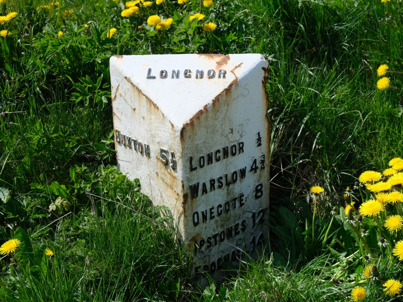
3/48 Milepost (Longnor
- half mile)
- II
Milepost. Early C20. Cast iron. Approximately 800mm high of triangular
plan, inclined head, inscribed "LONGNOR" left side inscribed "BUXTON 6½/"
and right"LONGNOR ;/WARSLOW 4¾/ONECOTE 8/IPSTONES 12/FROGHALL 14/
CHEADLE 17".
Listing NGR: SK0833765651
External links are from the relevant listing authority and, where applicable, Wikidata. Wikidata IDs may be related buildings as well as this specific building. If you want to add or update a link, you will need to do so by editing the Wikidata entry.


Other nearby listed buildings
