Approximate Location Map
Large Map »
Latitude: 50.9534 / 50°57'12"N
Longitude: 0.7352 / 0°44'6"E
OS Eastings: 592205
OS Northings: 120666
OS Grid: TQ922206
Mapcode National: GBR RZ1.0PP
Mapcode Global: FRA D6FL.88N
Plus Code: 9F22XP3P+83
Entry Name: 7, Landgate
Listing Date: 11 September 1972
Grade: II
Source: Historic England
Source ID: 1262622
English Heritage Legacy ID: 434571
ID on this website: 101262622
Location: Rye, Rother, East Sussex, TN31
County: East Sussex
District: Rother
Civil Parish: Rye
Built-Up Area: Rye
Traditional County: Sussex
Lieutenancy Area (Ceremonial County): East Sussex
Church of England Parish: Rye
Church of England Diocese: Chichester
Tagged with: Building
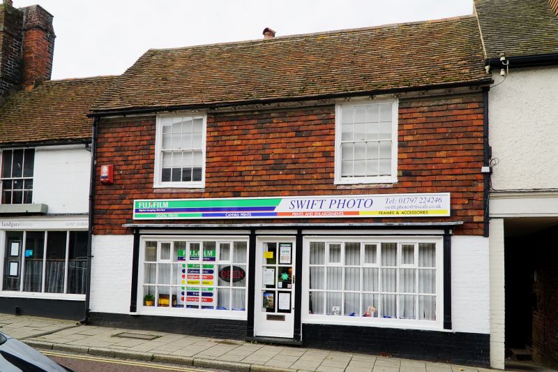
1.
1578 LANDGATE
(West side)
No 7
TQ 9220 1/230
II GV
2.
Late C18 facade. 2 storeys. 2 windows. Top floor has painted tile hanging,
bottom floor painted brick. Tiled roof. House has a dentil eaves cornice.
Sash windows have original glazing bars. Later shop front.
Nos 4 to 7 (consec) and Nos 10 to 13 (consec) form a group.
Listing NGR: TQ9221320669
External links are from the relevant listing authority and, where applicable, Wikidata. Wikidata IDs may be related buildings as well as this specific building. If you want to add or update a link, you will need to do so by editing the Wikidata entry.


Other nearby listed buildings
