Approximate Location Map
Large Map »
Latitude: 53.3678 / 53°22'3"N
Longitude: -2.0008 / 2°0'2"W
OS Eastings: 400044
OS Northings: 385654
OS Grid: SK000856
Mapcode National: GBR GYGH.MG
Mapcode Global: WHBB5.7MH2
Plus Code: 9C5V9X9X+4M
Entry Name: Nos 34 and 36 (Former Bank Building and Attached Boundary Wall)
Listing Date: 18 May 1990
Last Amended: 2 May 1991
Grade: II
Source: Historic England
Source ID: 1263554
English Heritage Legacy ID: 81898
ID on this website: 101263554
Location: New Mills, High Peak, Derbyshire, SK22
County: Derbyshire
District: High Peak
Civil Parish: New Mills
Built-Up Area: New Mills
Traditional County: Derbyshire
Lieutenancy Area (Ceremonial County): Derbyshire
Church of England Parish: New Mills St George
Church of England Diocese: Derby
Tagged with: Building Italianate architecture
In the entry for the following:
NEW MILLS HIGH STREET
1.
5172
SK 0085/0185 1/106 former bank building
and attached boundary
wall at attached
cottages
II
the address shall be amended to read:
NEW MILLS HIGH STREET
No. 34
(former Bank Building)
and attached boundary wall
------------------------------------
In the entry for the following:
NEW MILLS HIGH STREET
1/106
No. 34
(former Bank Building)
and attached boundary wall
the address shall be amended to read:
NEW MILLS HIGH STREET
Nos 34 and 36
(former Bank Building
and attached boundary wall)
------------------------------------
The following items shall be added:
NEW MILLS HIGH STREET
1.
5172
SK 0085/0185 1/106 former bank building
and attached boundary
wall at attached
IT cottages
2.
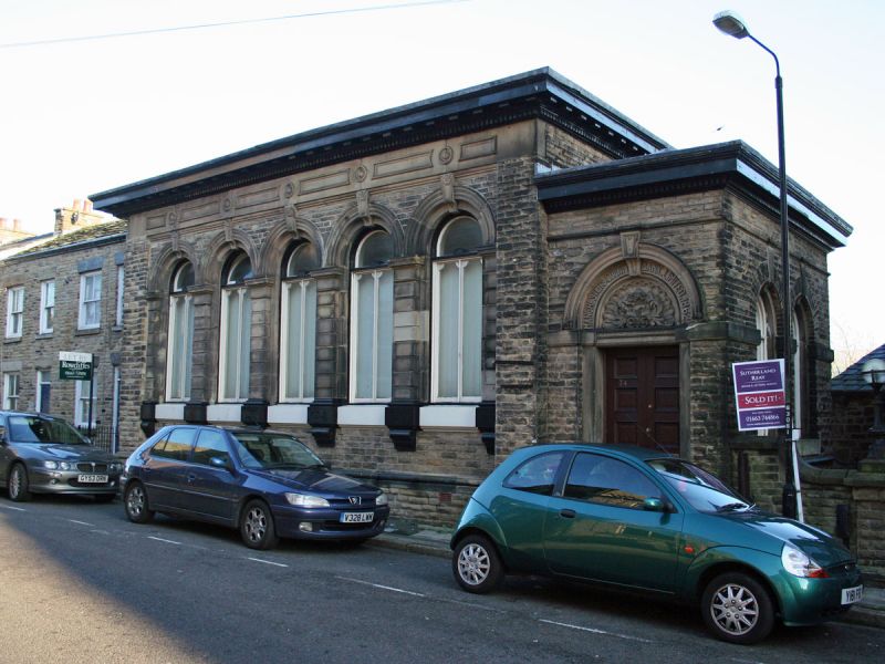
Commercial building above cottages, formerly banking hall and associated
housing, the banking hall having been formed fron remodelled and extended
cottages at upper street level with contemporary cottages below entered at
lower street level. Banking Hall dated 1862, remaining parts at upper and
lower levels mid to late C18 with C19 alterations. North West (upper)
elevation. Regularly coursed grit stone, laid in narrow courses, rising
from a plinth, which is moulded at the banking hall end. Gritstone ashlar
dressings throughout, highly decorated in the banking hall which has a
moulded eaves cornice. West slated and stone slated roofs with a stone
ridge stack. 3 bay range to north-west end a conversion to commercial
premises form a dwelling, with a single first floor sash window below a
wedge lintel, and two tall semi-circular
headed windows with an advanced keyblock. The window is divided into
two lights, with a slender timber mullion terminating at a transom below
the fanlight head. Advanced hipped roofed banking hall, with arcaded
front, comprising five semi-circular full height windows, below a
moulded frieze, and a boldly oversailing dentilled eaves cornice the
ashlar piers between the windows are deeply jointed, and rise from a
broad cill band, with brackets to the base of each pier. Lower entrance
porch to south-east end with shallow hipped roof, and semi-circular
headed doorway. Inscription to doorway head reads MANCHESTER COUNTY
BANK LTD 1862. Carved and decorative tympanium, with band course
linking flat head to double doorway each door with 4 raised and field
panels. Attached flanking wall with ramped parapet and square terminal
pier, and moulded coping, the pier surmounted by the base of a cast iron
lamp. Rear elevation of three storeys north-west part formed from C18
dwelling and of weather shot masonry. 3 semi-circular headed windows to
second floor but lower two storey part with 3 two-light flush mullioned
windows. First floor level two ground floor doorways with plain flush
surrounds and plain planked doors, each flanked by two light flush
mullioned windows all with C20 casements. Banking hall with panelled
ceiling beams and egg and dart cornices.
Listing NGR: SK0004485654
External links are from the relevant listing authority and, where applicable, Wikidata. Wikidata IDs may be related buildings as well as this specific building. If you want to add or update a link, you will need to do so by editing the Wikidata entry.


Other nearby listed buildings
