Latitude: 51.6852 / 51°41'6"N
Longitude: 0.4352 / 0°26'6"E
OS Eastings: 568438
OS Northings: 201299
OS Grid: TL684012
Mapcode National: GBR NJR.8VX
Mapcode Global: VHJK7.HXF0
Plus Code: 9F32MCPP+33
Entry Name: Martin's Farmhouse
Listing Date: 29 December 1952
Grade: II
Source: Historic England
Source ID: 1265086
English Heritage Legacy ID: 426050
ID on this website: 101265086
Location: Margaretting Tye, Chelmsford, Essex, CM4
County: Essex
District: Chelmsford
Civil Parish: Margaretting
Traditional County: Essex
Lieutenancy Area (Ceremonial County): Essex
Church of England Parish: Margaretting St Margaret
Church of England Diocese: Chelmsford
Tagged with: Farmhouse
This list entry was subject to a Minor Amendment on 9 December 2024 to correct a typo in the description and reformat the and text to current standards
TL 60 SE
12/388
MARGARETTING
MARGARETTING TYE
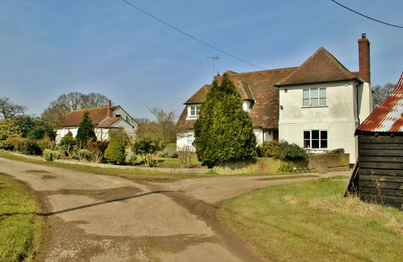
Martin's Farmhouse
29.12.52.
II
A timber-framed and plastered house of C17 origin, with a cross wing at the east end. the main block is very much altered. The cross wing is two storeys and the main block is one storey and attics, the windows are double-hung rushes, some with glazing bars, on the cross wing and casements on the main block. Roof tiled, with a C20 gabled dormer windows to the main block and hipped on the cross wing.
Listing NGR: TL6843801299
External links are from the relevant listing authority and, where applicable, Wikidata. Wikidata IDs may be related buildings as well as this specific building. If you want to add or update a link, you will need to do so by editing the Wikidata entry.


Other nearby listed buildings