Approximate Location Map
Large Map »
Latitude: 50.9866 / 50°59'11"N
Longitude: -0.611 / 0°36'39"W
OS Eastings: 497590
OS Northings: 121719
OS Grid: SU975217
Mapcode National: GBR FGL.2B8
Mapcode Global: FRA 96LH.RT3
Plus Code: 9C2XX9PQ+JJ
Entry Name: Chantry Cottage
Listing Date: 22 May 1985
Grade: II
Source: Historic England
Source ID: 1266113
English Heritage Legacy ID: 422942
ID on this website: 101266113
Location: Petworth, Chichester, West Sussex, GU28
County: West Sussex
District: Chichester
Civil Parish: Petworth
Built-Up Area: Petworth
Traditional County: Sussex
Lieutenancy Area (Ceremonial County): West Sussex
Church of England Parish: Petworth St Mary
Church of England Diocese: Chichester
Tagged with: Cottage
SU 9721
29/358
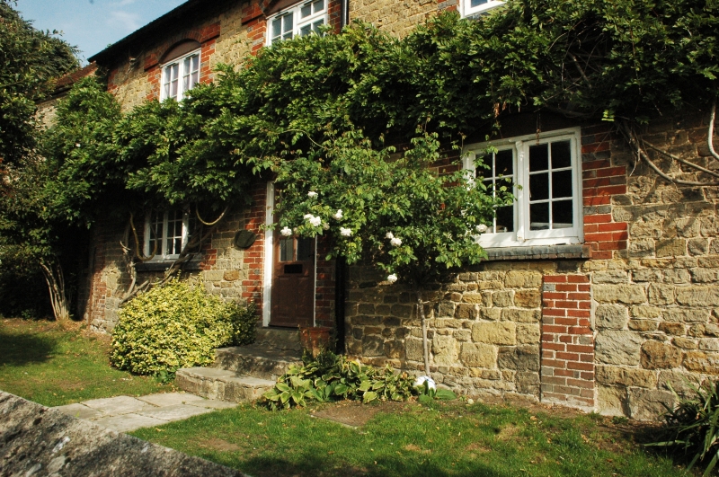
PETWORTH,
PARK ROAD,
Chantry Cottage
(Formerly listed as Mean-Veor)
II
House. Early C19. two Storeys. Four windows. Coursed stone with red brick
dressings and quoins. Tiled roof. Casement windows.
Listing NGR: SU9759021719
External links are from the relevant listing authority and, where applicable, Wikidata. Wikidata IDs may be related buildings as well as this specific building. If you want to add or update a link, you will need to do so by editing the Wikidata entry.


Other nearby listed buildings
