Approximate Location Map
Large Map »
Latitude: 51.5099 / 51°30'35"N
Longitude: -0.1491 / 0°8'56"W
OS Eastings: 528545
OS Northings: 180621
OS Grid: TQ285806
Mapcode National: GBR BD.PX
Mapcode Global: VHGQZ.C9KV
Plus Code: 9C3XGV52+X9
Entry Name: Vestry and Presbytery
Listing Date: 1 December 1987
Grade: II
Source: Historic England
Source ID: 1267199
English Heritage Legacy ID: 419434
ID on this website: 101267199
Location: Mayfair, Westminster, London, W1K
County: London
District: City of Westminster
Electoral Ward/Division: West End
Parish: Non Civil Parish
Built-Up Area: City of Westminster
Traditional County: Middlesex
Lieutenancy Area (Ceremonial County): Greater London
Church of England Parish: St George, Hanover Square
Church of England Diocese: London
Tagged with: Architectural structure
TQ 2880 NE CITY OF WESTMINSTER MOUNT STREET W1
69/125 (south side)
No 114 (Vestry and
Presbytery)
GV
II
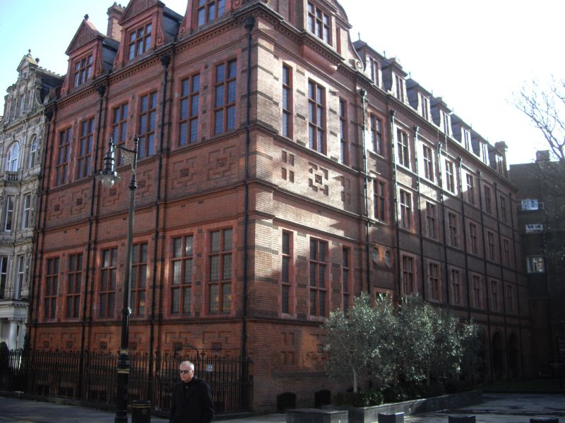
Vestry hall and Presbytery. 1886-88 by A E Purdie. Dark red machined brick and lavish
dark red terracotta dressings; slate roofs. Two main storeys over basement to vestry
hall and chapel block facing Mount Street. Three major bays defined by thin projecting
piers, each bay containing pairs of mullioned and double transomed leaded casements
under flat arches to both main floors; sunk panel aprons, moulded sill bands and string
courses. Cornice breaking forward over piers. Over each bay a gabled lucarne with
flanking scrolls. West elevation: the 2 storey block is expressed as a single major
gabled bay with same details. Its continuation, the Presbytery within the same overall
height has 4 storeys and 7 bays. The 4 bays to right with open arcade on ground
floor. Mullioned-transomed leaded casements. Moulded string and sill courses and
cornice as before with each bay surmounted by a lucarne dormer. Prominent ribbed
chimney stacks. Gothicised iron railings to wide basement area and to entrance steps
into arcade. Included for group interest as part of the 1880s -90s rebuilding of
Mount Street for the Grosvenor Estate.
Listing NGR: TQ2854580621
External links are from the relevant listing authority and, where applicable, Wikidata. Wikidata IDs may be related buildings as well as this specific building. If you want to add or update a link, you will need to do so by editing the Wikidata entry.


Other nearby listed buildings
