Approximate Location Map
Large Map »
Latitude: 50.7293 / 50°43'45"N
Longitude: -3.5202 / 3°31'12"W
OS Eastings: 292805
OS Northings: 93283
OS Grid: SX928932
Mapcode National: GBR P1.8GV5
Mapcode Global: FRA 37J4.SJG
Plus Code: 9C2RPFHH+PW
Entry Name: St Anne's Almhouses
Listing Date: 29 January 1953
Grade: II
Source: Historic England
Source ID: 1267540
English Heritage Legacy ID: 418400
ID on this website: 101267540
Location: St James', Exeter, Devon, EX4
County: Devon
District: Exeter
Electoral Ward/Division: Newtown and St Leonard's
Parish: Non Civil Parish
Built-Up Area: Exeter
Traditional County: Devon
Lieutenancy Area (Ceremonial County): Devon
Church of England Parish: Exeter St James
Church of England Diocese: Exeter
Tagged with: Architectural structure
SX9393
871/12/352
OLD TIVERTON ROAD (east side)
St Anne's Almhouses
29-JAN-53
GV
II
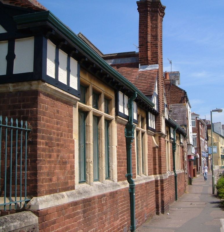
Almshouses. C16; restored 1838; partly rebuilt 1907-9 by W.D Caröe. Heavitree stone; partly rebuilt in brick, stone and timber-framing. Clay plain tile roof with gable-ends, sprocketed eaves and pierced ridge tiles. Brick gable-end stacks with corbelled brick tops.
PLAN: L-shaped on plan range of almshouses, the west end rebuilt 1907-9 in free Tudor style.
EXTERIOR: one storey and attic. Ground floor brick with stone dressings, stone window frames, plinth and stringcourses, with timber-framing above; panelled doors with canopies on shaped brackets. C16 wing on left (east) with sashes on ground floor, C20 flat roof dormers above and chamfered arch doorway on left; on left (north) corner a stone arch linking almshouses to chapel [qv].
Rear (south) facing road, 2:1:1:2 bays, large two- and three-light stone mullion windows with transoms, and timber-framed gable at centre with brick stack. C16 stone range on right (east) with sashes, gable on right and stone stacks heightened in brick.
INTERIORS: not inspected.
Listing NGR: SX9279893280
External links are from the relevant listing authority and, where applicable, Wikidata. Wikidata IDs may be related buildings as well as this specific building. If you want to add or update a link, you will need to do so by editing the Wikidata entry.


Other nearby listed buildings
