Approximate Location Map
Large Map »
Latitude: 53.1032 / 53°6'11"N
Longitude: -2.0518 / 2°3'6"W
OS Eastings: 396627
OS Northings: 356220
OS Grid: SJ966562
Mapcode National: GBR 24N.J2K
Mapcode Global: WHBCH.G85C
Plus Code: 9C5V4W3X+77
Entry Name: Stable Block at Westwood Hall Farm
Listing Date: 10 March 1975
Grade: II
Source: Historic England
Source ID: 1268549
English Heritage Legacy ID: 461712
ID on this website: 101268549
Location: Westwood, Staffordshire Moorlands, Staffordshire, ST13
County: Staffordshire
District: Staffordshire Moorlands
Civil Parish: Leek
Traditional County: Staffordshire
Lieutenancy Area (Ceremonial County): Staffordshire
Church of England Parish: Leek St Edward the Confessor
Church of England Diocese: Lichfield
Tagged with: Stable
LEEK
SJ95NE WESTWOOD PARK AVENUE
611-1/1/139 (West side)
10/03/75 Stable block at Westwood Hall Farm
II
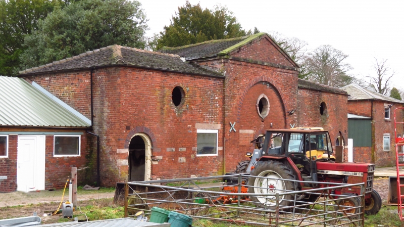
Stable block. c1780. Brick with plain-tiled and slate roofs.
Symmetrically planned with 3-bay central block linked by
curtain wall (with later lean-to stabling) to outer single-bay
pavilions.
EXTERIOR: one and two storeys central range has advanced
pedimented central gable, with full-height relieving arch over
central round-arched doorway. Circular pitching-eye above,
with stone dressings and keystones. Brick string course
pediments the gable. Inserted window alongside doorway. Single
round-arched doorways in outer bays, and simple brick circular
pitching-eyes above. Inserted doors and windows each side.
Outer pavilions have round-arched doorways flanking windows
with segmental brick heads, round-arched upper window in
left-hand pavilion, inserted window to right. Round-headed
windows in rear elevation, which is articulated as
1-1-2-1-2-1-1 bays, mirroring the main elevation with pediment
over central bay of principal building.
INTERIOR: not inspected.
The stables form part of a courtyard farm complex, apparently
laid out and planned in the later C18 incoporating traces of
earlier buildings, and extended subsequently by the insertion
of buildings in the central space.
Listing NGR: SJ9662756220
External links are from the relevant listing authority and, where applicable, Wikidata. Wikidata IDs may be related buildings as well as this specific building. If you want to add or update a link, you will need to do so by editing the Wikidata entry.


Other nearby listed buildings
