Approximate Location Map
Large Map »
Latitude: 51.5838 / 51°35'1"N
Longitude: -2.0989 / 2°5'56"W
OS Eastings: 393240
OS Northings: 187223
OS Grid: ST932872
Mapcode National: GBR 2QZ.Q4S
Mapcode Global: VH95S.KGQ6
Plus Code: 9C3VHWM2+GC
Entry Name: 18 and 20, Gloucester Street
Listing Date: 1 July 1976
Grade: II
Source: Historic England
Source ID: 1269414
English Heritage Legacy ID: 460784
ID on this website: 101269414
Location: Malmesbury, Wiltshire, SN16
County: Wiltshire
Civil Parish: Malmesbury
Built-Up Area: Malmesbury
Traditional County: Wiltshire
Lieutenancy Area (Ceremonial County): Wiltshire
Church of England Parish: Malmesbury and Brokenborough
Church of England Diocese: Bristol
Tagged with: Building
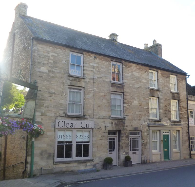
MALMESBURY
ST9387 GLOUCESTER STREET
758-1/4/121 (West side)
01/07/76 Nos.18 AND 20
GV II
Medieval shop or warehouse, beneath pair of houses and shop.
C15 undercroft beneath late C17 rear range, and mid C19 front.
Coursed, squared limestone facade with rubble returns and
rear, party wall and gable stacks and a slate roof with stone
slate to the rear.
PLAN: double-depth, No.20 based on former C17 house.
EXTERIOR: each of 3 storeys and basement; 2-window range. An
unequal pair: No.20 narrower with a C19 shop front with
cornice, triple 4/4-pane sashes and a left-hand door, and
deeply-set 6/6-pane sashes above; No.18 has 2 doorways to the
right with rectangular overlights and half-glazed doors,
paired 2/2-pane ground-floor, and similar upper sashes.
Rear C17 gabled range to No.20 forms a pair with No.28/30
(qv), with a weathered band across both above the basement,
carved stone stacks, first-floor segmental-arched mullion
window, and gabled side dormer.
INTERIOR: details include a shallow, vaulted rubble undercroft
to No.20 with steps down from the street end, and a C17
splayed mullion rear window; chamfered and stopped ceiling
beams and collar trusses.
HISTORICAL NOTE: Undercroft converted for use as loop in town
wall which was incorporated into wall of Nos 28 and 30 (qv).
(Stirling D: Secular medieval buildings in Malmesbury, Wilts,
1150-1547: 1986-: 10).
Listing NGR: ST9324087221
External links are from the relevant listing authority and, where applicable, Wikidata. Wikidata IDs may be related buildings as well as this specific building. If you want to add or update a link, you will need to do so by editing the Wikidata entry.


Other nearby listed buildings
