Latitude: 54.2062 / 54°12'22"N
Longitude: -2.8952 / 2°53'42"W
OS Eastings: 341709
OS Northings: 479309
OS Grid: SD417793
Mapcode National: GBR 8M7S.0Y
Mapcode Global: WH83D.HJKT
Plus Code: 9C6V6443+FW
Entry Name: South Lodge to Castle Head
Listing Date: 2 May 1975
Last Amended: 12 July 1996
Grade: II
Source: Historic England
Source ID: 1269680
English Heritage Legacy ID: 460529
ID on this website: 101269680
Location: Westmorland and Furness, Cumbria, LA11
County: Westmorland and Furness
District: South Lakeland
Civil Parish: Grange-over-Sands
Traditional County: Lancashire
Lieutenancy Area (Ceremonial County): Cumbria
Church of England Parish: Grange-over-Sands St Paul
Church of England Diocese: Carlisle
Tagged with: Architectural structure
GRANGE-OVER-SANDS
SD47NW LINDALE ROAD 705-1/2/22 (East side) 02/05/75 South Lodge to Castle Head (Formerly Listed as: LINDALE ROAD South Lodge to Castle Head, with adjoining gate piers)
GV II
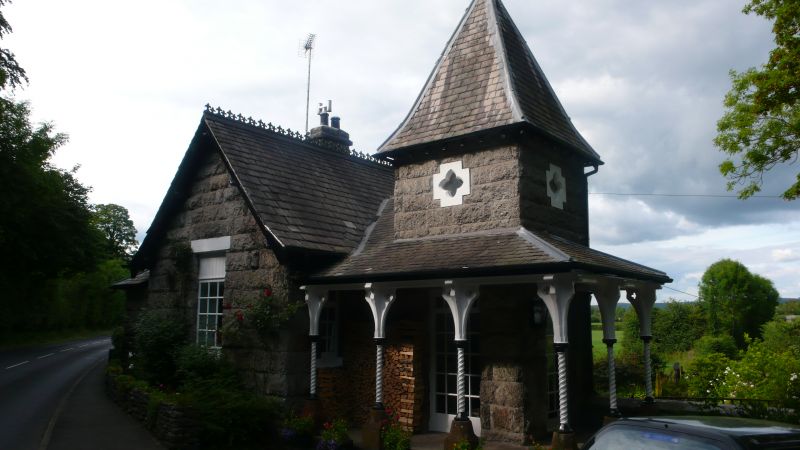
Lodge to Castle Head (qv). Mid to late C19. Rock-faced limestone with slate roof. Single storey, with basement to rear. A gable faces west towards the main road and has a C20 casement window with glazing bars. Similar window set back to the left rises into a hipped dormer. The left-hand return wall is of 2 windows above windows which light the basement and has similar dormers. At the right, next to the drive entrance, is a tower of square plan with a pyramid roof, surrounded on 2 sides by a slated verandah. It has glazed door openings in its front and right-hand walls, and quatrefoiled openings in both walls above the verandah. The verandah is carried on 6 cast-iron barleysugar columns, on sandstone bases, which support arched timber brackets which are pierced with quatrefoils.
Listing NGR: SD4170979309
External links are from the relevant listing authority and, where applicable, Wikidata. Wikidata IDs may be related buildings as well as this specific building. If you want to add or update a link, you will need to do so by editing the Wikidata entry.


Other nearby listed buildings