Latitude: 54.1957 / 54°11'44"N
Longitude: -3.0954 / 3°5'43"W
OS Eastings: 328631
OS Northings: 478321
OS Grid: SD286783
Mapcode National: GBR 6MTX.NQ
Mapcode Global: WH725.FS7X
Plus Code: 9C6R5WW3+7R
Entry Name: Former Midland Bank
Listing Date: 19 April 1996
Grade: II
Source: Historic England
Source ID: 1270211
English Heritage Legacy ID: 459996
ID on this website: 101270211
Location: Ulverston, Westmorland and Furness, Cumbria, LA12
County: Cumbria
District: South Lakeland
Civil Parish: Ulverston
Built-Up Area: Ulverston
Traditional County: Lancashire
Lieutenancy Area (Ceremonial County): Cumbria
Church of England Parish: Ulverston St Mary with Holy Trinity
Church of England Diocese: Carlisle
Tagged with: Bank building
SD 2878,
626-1/3/95
ULVERSTON,
NEW MARKET STREET (west side),
Former Midland Bank
(Formerly listed as: Midland Bank)
II
Bank. Late C19. Sandstone ashlar on limestone plinth, with
slate roof.
Facade asymmetrical, of 3 storeys, with one window to the left
of the doorway and 2 to the right on the ground and first
floors, and 6 windows on the 2nd floor. On the ground floor
the windows are tripartite with fixed lights separated by
mullions with sunken panels, and on the 1st and 2nd floors
they are sashed without glazing bars in architraves with sill
bands. The 1st-floor windows have paired sashes separated by
mullions, and the lintels have incised decoration. The doorway
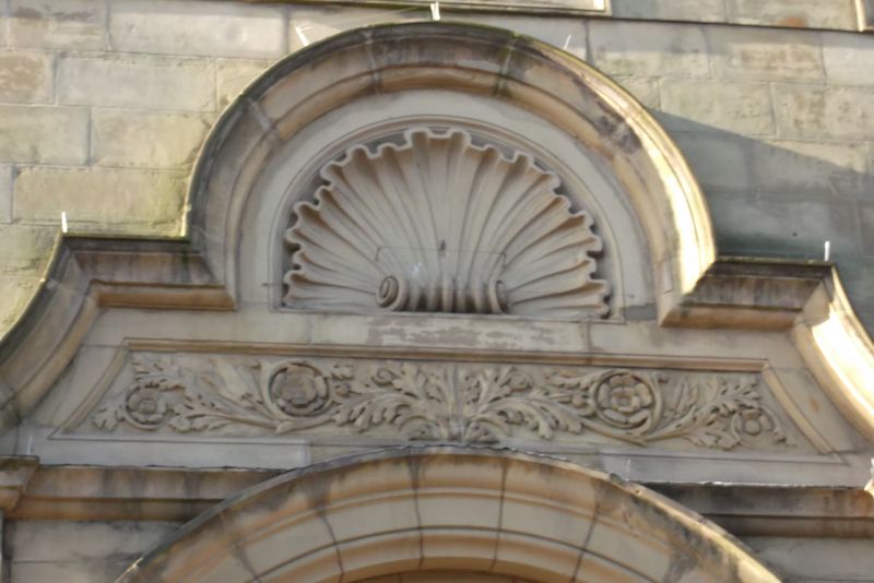
is flanked by pilasters. Above, a carved panel occupies the
full height of the 1st floor. A semicircular architrave
moulding encloses foliage and an inscription ('Lc Bc') and is
itself enclosed by pilasters supporting a moulded pediment
treated like a shaped gable, with a carved shell and foliage
decoration. Above the main cornice is a panel inscribed
'BANK', with pilasters, supporting volutes, a central
cartouche above a cornice, and antefixae to each side.
Listing NGR: SD2863178321
External links are from the relevant listing authority and, where applicable, Wikidata. Wikidata IDs may be related buildings as well as this specific building. If you want to add or update a link, you will need to do so by editing the Wikidata entry.


Other nearby listed buildings