Latitude: 52.2294 / 52°13'45"N
Longitude: -2.7398 / 2°44'23"W
OS Eastings: 349570
OS Northings: 259280
OS Grid: SO495592
Mapcode National: GBR FK.1M0K
Mapcode Global: VH84W.G7G8
Plus Code: 9C4V67H6+Q3
Entry Name: 33 and 35, Broad Street
Listing Date: 9 July 1976
Grade: II
Source: Historic England
Source ID: 1270315
English Heritage Legacy ID: 459627
ID on this website: 101270315
Location: Leominster, County of Herefordshire, HR6
County: County of Herefordshire
Civil Parish: Leominster
Built-Up Area: Leominster
Traditional County: Herefordshire
Lieutenancy Area (Ceremonial County): Herefordshire
Church of England Parish: Leominster
Church of England Diocese: Hereford
Tagged with: Building
LEOMINSTER
SO4959 BROAD STREET 808-1/1/62 (West side) 09/07/76 Nos.33 AND 35
GV II
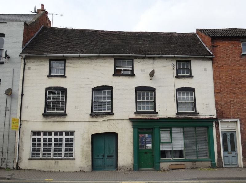
Houses. C18 front to C17 core. Painted brick; steep-pitched roof with old plain tiles; brick corner stack to rear. 3 storeys and cellar; 4-window range: late C19, 8/8 sashes in moulded cases under segmental arches; 3 late C19 3/3 sashes over; wall-plate. To right, C19 shop front with half-glazed panelled door and overlight to left; window with moulded glazing bars; moulded fascia-board and hood, on pilasters. C19 plank door in moulded frame under segmental arch; to left, C20 casement in altered opening, under 2 segmental arches; storey band. Passage to rear: exposed C17 or earlier timber-framing. Rear: box framing. Wing with timber-frame and plaster gable over roughcast; late C19 6/6 sash. Longer wing with angled brick corner stack; lattice-framed gable with tumbled-in brick infill; C20 window; 2-light casement. INTERIOR not inspected. (RCHME: Herefordshire: 120 (58,57)).
Listing NGR: SO4957059280
External links are from the relevant listing authority and, where applicable, Wikidata. Wikidata IDs may be related buildings as well as this specific building. If you want to add or update a link, you will need to do so by editing the Wikidata entry.


Other nearby listed buildings