Approximate Location Map
Large Map »
Latitude: 51.2883 / 51°17'17"N
Longitude: 0.2231 / 0°13'23"E
OS Eastings: 555117
OS Northings: 156700
OS Grid: TQ551567
Mapcode National: GBR VT.LXY
Mapcode Global: VHHPL.TW98
Plus Code: 9F3276QF+86
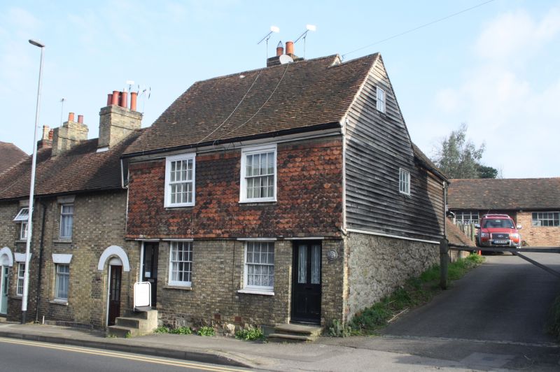
Entry Name: 55 and 57, High Street
Listing Date: 16 January 1975
Grade: II
Source: Historic England
Source ID: 1272845
English Heritage Legacy ID: 447392
ID on this website: 101272845
Location: Seal, Sevenoaks, Kent, TN15
County: Kent
District: Sevenoaks
Civil Parish: Seal
Built-Up Area: Sevenoaks
Traditional County: Kent
Lieutenancy Area (Ceremonial County): Kent
Church of England Parish: Seal St Peter and St Paul
Church of England Diocese: Rochester
Tagged with: Building
1.
5280 SEAL SEAL
High Street
(North Side)
Nos 55 & 57
TQ 5556 NW 28/1010
II
2.
C17 or earlier timber framed building with C19 front. 2 storeys. Stone plinth.
Yellow brick with tile hanging above. Boarded eaves and tile roof. Sash windows
with glazing bars. Side elevation of random stone with weatherboarding above.
Listing NGR: TQ5511556702
External links are from the relevant listing authority and, where applicable, Wikidata. Wikidata IDs may be related buildings as well as this specific building. If you want to add or update a link, you will need to do so by editing the Wikidata entry.


Other nearby listed buildings
