Approximate Location Map
Large Map »
Latitude: 52.8063 / 52°48'22"N
Longitude: -2.0247 / 2°1'28"W
OS Eastings: 398434
OS Northings: 323191
OS Grid: SJ984231
Mapcode National: GBR 28C.4XT
Mapcode Global: WHBDV.WQ1H
Plus Code: 9C4VRX4G+G4
Entry Name: Farmbuildings at Tixall Farm
Listing Date: 31 May 1988
Grade: II
Source: Historic England
Source ID: 1273249
English Heritage Legacy ID: 445732
ID on this website: 101273249
Location: Tixall, Stafford, Staffordshire, ST18
County: Staffordshire
District: Stafford
Civil Parish: Tixall
Traditional County: Staffordshire
Lieutenancy Area (Ceremonial County): Staffordshire
Church of England Parish: Tixall St John the Baptist
Church of England Diocese: Lichfield
Tagged with: Agricultural structure
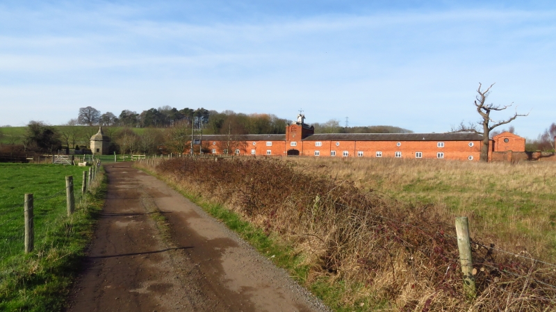
TIXALL Farmbuildings at
1.
5373
Tixall Farm
SJ 92 SE 19/5A
II GV
2.
Farm buildings, c1830. Built for the Clifford family of Tixall Hall. Red brick
with ashlar and brick dressings. Slate hipped roofs. Quadrangular plan. Main
street front 2 storeys and 17 bays, with slightly projecting 3 bay centre.
Central segmental carriage arch with above a 3 light casement, and above again a
square tower containing a pigeoncote with corner turrets with pyramidal caps.
The tower has an ashlar plaque with a coat of arms, and above a round headed
recessed panel with flight perches and openings. The tower is topped by a
hipped slate roof and an ornate wooden cupola with weather vane. Either side
are single 4 light windows, with 3 light casements above. Beyond to either side
are 7, 4 light windows with 3 circular pitching eyes above. To the north-east a
large hay barn, joined by a buttressed wall. The hay barn has 5 large segmental
arches to either side and a single arch at either end, the whole is topped by a
hipped slate roof with continuous ventilator. To the rear of the main range are
3 large cowsheds with round headed arched entrances. Adjoining this to the
north-east is a large threshing barn now partially demolished, only one segmental
threshing arch survives. To the north, the stable range has a 2 storey 7 bay
centre, under a hipped slate roof, with a central segmental arch flanked by
stables with lofts above. Either side are single storey wings, that to the left
has 6 implement sheds, and that to the right further stables.
Listing NGR: SJ9841223142
External links are from the relevant listing authority and, where applicable, Wikidata. Wikidata IDs may be related buildings as well as this specific building. If you want to add or update a link, you will need to do so by editing the Wikidata entry.


Other nearby listed buildings
