Approximate Location Map
Large Map »
Latitude: 52.0211 / 52°1'16"N
Longitude: -2.2178 / 2°13'3"W
OS Eastings: 385153
OS Northings: 235878
OS Grid: SO851358
Mapcode National: GBR 1J8.B3M
Mapcode Global: VH93L.HGXG
Plus Code: 9C4V2QCJ+CV
Entry Name: Gunnice Farmhouse
Listing Date: 30 May 1984
Grade: II
Source: Historic England
Source ID: 1273984
English Heritage Legacy ID: 416371
ID on this website: 101273984
Location: Malvern Hills, Worcestershire, GL20
County: Worcestershire
District: Malvern Hills
Civil Parish: Longdon
Traditional County: Worcestershire
Lieutenancy Area (Ceremonial County): Worcestershire
Church of England Parish: Longdon
Church of England Diocese: Worcester
Tagged with: Farmhouse
SO 83 NE LONGDON GULLERS END
2/16
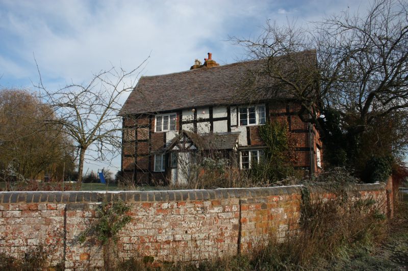
Gunnice Farmhouse
GV
II
Farmhouse C16 timber-frame and red brick, some painted. Plain tile roof. 2 and a
half storeys. T plan. Front range 11 x 4 panels, 2 window range and central door in
C19 tiles and timber-framed porch. Rear wing has fine brick stack on North roof
slope, triple star-plan shafts. Later East end wall stack. On South side a large
timber-framed dormer gable, 2-light floor casements and ground floor modern window and
door. Modern flat-roofed addition in angle between the two ranges.
Listing NGR: SO8515335878
External links are from the relevant listing authority and, where applicable, Wikidata. Wikidata IDs may be related buildings as well as this specific building. If you want to add or update a link, you will need to do so by editing the Wikidata entry.


Other nearby listed buildings
