Approximate Location Map
Large Map »
Latitude: 51.3786 / 51°22'42"N
Longitude: 0.2244 / 0°13'27"E
OS Eastings: 554901
OS Northings: 166740
OS Grid: TQ549667
Mapcode National: GBR VM.TFQ
Mapcode Global: VHHP6.TMZ1
Plus Code: 9F3296HF+CP
Entry Name: South Hall
Listing Date: 1 June 1967
Last Amended: 22 October 1982
Grade: II
Source: Historic England
Source ID: 1274426
English Heritage Legacy ID: 415098
ID on this website: 101274426
Location: Farningham, Sevenoaks, Kent, DA4
County: Kent
District: Sevenoaks
Civil Parish: Farningham
Built-Up Area: Eynsford
Traditional County: Kent
Lieutenancy Area (Ceremonial County): Kent
Church of England Parish: Farningham St Peter and St Paul
Church of England Diocese: Rochester
Tagged with: House
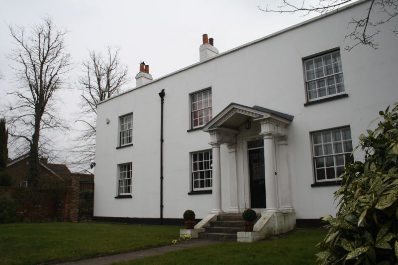
FARNINGHAM HIGH STREET
1.
5280 (south-west side)
South Hall
(formerly listed as
Southall)
TQ 5466 10/109 1.6.67
II GV
2.
Early C19 house. Two storeys stuccoed with slate roof. Stone parapet. Five
sashes with glazing bars intact, the end bay is of lower elevation. Good wide
porch with pediment and triglyph frieze approached up 4 steps.
Listing NGR: TQ5490466743
External links are from the relevant listing authority and, where applicable, Wikidata. Wikidata IDs may be related buildings as well as this specific building. If you want to add or update a link, you will need to do so by editing the Wikidata entry.


Other nearby listed buildings
