Approximate Location Map
Large Map »
Latitude: 50.854 / 50°51'14"N
Longitude: -0.5322 / 0°31'55"W
OS Eastings: 503416
OS Northings: 107075
OS Grid: TQ034070
Mapcode National: GBR GKK.B8R
Mapcode Global: FRA 96SV.0J9
Plus Code: 9C2XVF39+H4
Entry Name: Barn to the West of River Coppice
Listing Date: 20 September 1984
Grade: II
Source: Historic England
Source ID: 1274515
English Heritage Legacy ID: 414752
ID on this website: 101274515
Location: Warningcamp, Arun, West Sussex, BN18
County: West Sussex
District: Arun
Civil Parish: Warningcamp
Traditional County: Sussex
Lieutenancy Area (Ceremonial County): West Sussex
Church of England Parish: Lyminster St Mary Magdalene
Church of England Diocese: Chichester
Tagged with: Barn
TQ OONW WARNINGCAMP THE STREET
9/210
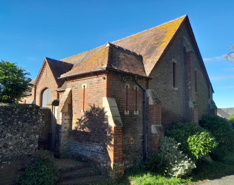
Barn to the west of
River Coppice
II
Similar to Barns at Wepham (Burpham) and South Stoke. C19 Barn built by the Duke of
Norfolk in the tradition of a medieval tithe-barn. Two storeys. Four bays, each
flanked by buttresses. Red brick. Eaves cornice of brick cogging. Tiled roof.
Four-centred open brick arches on ground floor. Casement windows above. The east
side has only one storey owing to the slope of the ground and a gabled portion forming
a loft entrance two feet above the ground. Small hipped projection at north east
angle.
Listing NGR: TQ0341607075
External links are from the relevant listing authority and, where applicable, Wikidata. Wikidata IDs may be related buildings as well as this specific building. If you want to add or update a link, you will need to do so by editing the Wikidata entry.


Other nearby listed buildings
