Approximate Location Map
Large Map »
Latitude: 53.6391 / 53°38'20"N
Longitude: -1.9 / 1°53'59"W
OS Eastings: 406710
OS Northings: 415852
OS Grid: SE067158
Mapcode National: GBR HV5C.G6
Mapcode Global: WHB8V.SSFJ
Plus Code: 9C5WJ4Q2+M2
Entry Name: Gatepiers and Burial Ground Walls to Pole Moor Baptist Chapel
Listing Date: 30 April 1982
Grade: II
Source: Historic England
Source ID: 1274888
English Heritage Legacy ID: 413888
ID on this website: 101274888
Location: Kirklees, West Yorkshire, HD3
County: Kirklees
Electoral Ward/Division: Colne Valley
Parish: Non Civil Parish
Traditional County: Yorkshire
Lieutenancy Area (Ceremonial County): West Yorkshire
Church of England Parish: Slaithwaite with East Scammonden St James
Church of England Diocese: Leeds
Tagged with: Gatepost
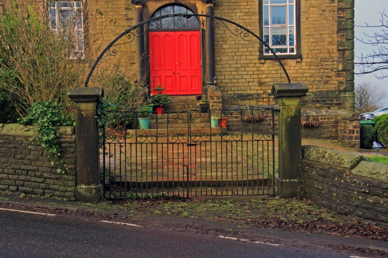
SE 067 158 POLE GATE
Pole Moor
2/517
Gatepiers and Burial
30.4.82 Ground Walls to Pole Moor
Baptist Chapel
GV II
c.1838. Dry stone wall to burial ground with pediment capped ashlar gatepiers,
axial to chapel entrance with simple wrought iron overthrow.
Listing NGR: SE0671015852
External links are from the relevant listing authority and, where applicable, Wikidata. Wikidata IDs may be related buildings as well as this specific building. If you want to add or update a link, you will need to do so by editing the Wikidata entry.


Other nearby listed buildings
