Approximate Location Map
Large Map »
Latitude: 51.1456 / 51°8'44"N
Longitude: 0.9285 / 0°55'42"E
OS Eastings: 604933
OS Northings: 142560
OS Grid: TR049425
Mapcode National: GBR SY9.1L5
Mapcode Global: VHKKP.1GQM
Plus Code: 9F324WWH+6C
Entry Name: Court Lodge and Garden Wall
Listing Date: 16 February 1989
Grade: II
Source: Historic England
Source ID: 1275572
English Heritage Legacy ID: 411822
ID on this website: 101275572
Location: Hinxhill, Ashford, Kent, TN25
County: Kent
District: Ashford
Civil Parish: Wye with Hinxhill
Traditional County: Kent
Lieutenancy Area (Ceremonial County): Kent
Tagged with: Architectural structure
TR 04 SW WYE HINXHILL
3/271 Court Lodge and
garden wall
GV II
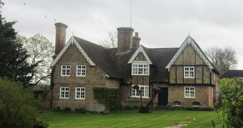
House. C16 or earlier, clad and extended C17 and C19. Timber framed, clad
and extended with red brick, part in irregular English bond. Plain tiled
roof. One storey and attic central block with 2 storey projecting wings
with basement to right. Plinth, with jetty to right hand block and plat
band to left hand block. Gabled wings with C19 pierced barge boards with
pendants. Centre block with bay window/half-dormer, with fine C17 moulded
bargeboard on egg and tongue cornice. Large moulded stack cluster to
centre left, and projecting and offset stack to end left; third stack to
centre rear. Two mullioned and transomed wooden casements on each floor
to left with blocked ground floor opening one to each block on each floor
to right. Two basement openings to right wing. Plank and stud door to
centre right in reeded and moulded doorway (C19? in C16 style). Outshots
and tile hung gabled wings to rear, in same style as C19 gables to front
elevation. Interior: chamfered and stopped ceiling joists and inglenooks
(one with fireback dated 1656). Attached to left return and extending
some 50 yards and returned along roadside and again to west is C19 ragstone
garden wall, some 10 feet high, ramped down to roadside, and incorporating
brick gateway piers and overthrow with trellised door.
Listing NGR: TR0543142993
External links are from the relevant listing authority and, where applicable, Wikidata. Wikidata IDs may be related buildings as well as this specific building. If you want to add or update a link, you will need to do so by editing the Wikidata entry.


Other nearby listed buildings
