Approximate Location Map
Large Map »
Latitude: 50.9896 / 50°59'22"N
Longitude: 0.6066 / 0°36'23"E
OS Eastings: 583030
OS Northings: 124366
OS Grid: TQ830243
Mapcode National: GBR QWY.XVF
Mapcode Global: FRA D65H.D54
Plus Code: 9F22XJQ4+RJ
Entry Name: Hayes Farmhouse
Listing Date: 13 May 1987
Grade: II
Source: Historic England
Source ID: 1275641
English Heritage Legacy ID: 411601
ID on this website: 101275641
Location: Northiam, Rother, East Sussex, TN31
County: East Sussex
District: Rother
Civil Parish: Northiam
Built-Up Area: Northiam
Traditional County: Sussex
Lieutenancy Area (Ceremonial County): East Sussex
Church of England Parish: Northiam St Mary
Church of England Diocese: Chichester
Tagged with: Farmhouse
TQ 8224-8324 NORTHIAM MAIN STREET
(east side)
47/5
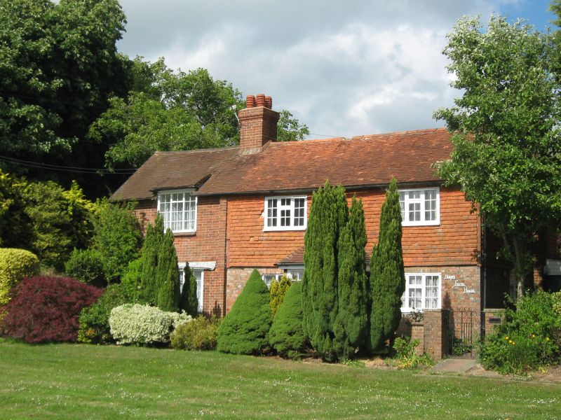
Hayes Farmhouse
GV II
Early C19. Two storeys. Two windows. Ground floor red brick, above tile-hung.
Tiled roof. Casement windows. Doorway with flat hood on brackets. Modern addi-
tion of one window-bay in red brick to north.
Listing NGR: TQ8303024366
External links are from the relevant listing authority and, where applicable, Wikidata. Wikidata IDs may be related buildings as well as this specific building. If you want to add or update a link, you will need to do so by editing the Wikidata entry.


Other nearby listed buildings
