Latitude: 51.5714 / 51°34'17"N
Longitude: -0.7774 / 0°46'38"W
OS Eastings: 484828
OS Northings: 186545
OS Grid: SU848865
Mapcode National: GBR D5W.G90
Mapcode Global: VHDWB.GRWQ
Plus Code: 9C3XH6CF+H2
Entry Name: 13, West Street
Listing Date: 31 January 1974
Grade: II
Source: Historic England
Source ID: 1275845
English Heritage Legacy ID: 411080
ID on this website: 101275845
Location: Marlow, Buckinghamshire, SL7
County: Buckinghamshire
Civil Parish: Marlow
Built-Up Area: Marlow
Traditional County: Buckinghamshire
Lieutenancy Area (Ceremonial County): Buckinghamshire
Church of England Parish: Great Marlow with Marlow Bottom, Little Marlow and Bisham
Church of England Diocese: Oxford
Tagged with: Building
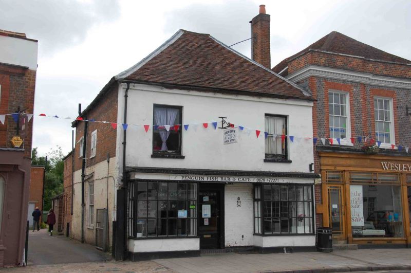
WEST STREET
1.
1385
(South East Side)
No 13
SU 8486 1/138
II GV
2.
C18 or early C19. 2 storey. Stucco, 2 windows. Glazing altered. Shop
front full length. Hipped old tile roof.
Nos 1 to 21 (odd) and the Ship Inn form a group.
Listing NGR: SU8483486539
External links are from the relevant listing authority and, where applicable, Wikidata. Wikidata IDs may be related buildings as well as this specific building. If you want to add or update a link, you will need to do so by editing the Wikidata entry.


Other nearby listed buildings