Approximate Location Map
Large Map »
Latitude: 50.9385 / 50°56'18"N
Longitude: 0.7631 / 0°45'47"E
OS Eastings: 594227
OS Northings: 119091
OS Grid: TQ942190
Mapcode National: GBR RZ8.1RH
Mapcode Global: FRA D6HM.F42
Plus Code: 9F22WQQ7+C6
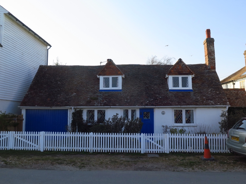
Entry Name: Harbour Lights
Listing Date: 13 May 1987
Grade: II
Source: Historic England
Source ID: 1276245
English Heritage Legacy ID: 410023
ID on this website: 101276245
Location: Rye Harbour, Rother, East Sussex, TN31
County: East Sussex
District: Rother
Civil Parish: Icklesham
Built-Up Area: Rye Harbour
Traditional County: Sussex
Lieutenancy Area (Ceremonial County): East Sussex
Church of England Parish: Rye
Church of England Diocese: Chichester
Tagged with: Architectural structure
TQ 91 NW ICKLESHAM RYE HARBOUR
25/11 Harbour Lights
GV II
C18. One storey and attic. Three windows. Two gabled dormers. Stuccoed.
Tiled roof. Casement windows. The south west end of ground floor has been
converted into a garage.
Listing NGR: TQ9422719091
External links are from the relevant listing authority and, where applicable, Wikidata. Wikidata IDs may be related buildings as well as this specific building. If you want to add or update a link, you will need to do so by editing the Wikidata entry.


Other nearby listed buildings
