Latitude: 54.7091 / 54°42'32"N
Longitude: -1.8158 / 1°48'56"W
OS Eastings: 411967
OS Northings: 534912
OS Grid: NZ119349
Mapcode National: GBR HFRZ.PQ
Mapcode Global: WHC4T.2WMT
Plus Code: 9C6WP55M+JM
Entry Name: Low Harperley Farmhouse
Listing Date: 31 January 1967
Grade: II*
Source: Historic England
Source ID: 1276972
English Heritage Legacy ID: 408020
ID on this website: 101276972
Location: County Durham, DL15
County: County Durham
Civil Parish: Wolsingham
Traditional County: Durham
Lieutenancy Area (Ceremonial County): County Durham
Church of England Parish: Crook
Church of England Diocese: Durham
Tagged with: Farmhouse
WOLSINGHAM A689 NZ 13 SW (South side, off) 31/332 Low Harperley Farmhouse 31.1.67 GV II*
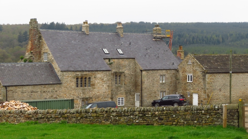
Originally known as Harperley Hall. Manor house, now farmhouse. C16 and C17, probably incorporating an earlier building; C18 alterations and additions. Sandstone rubble with ashlar dressings and quoins; stone-flagged roof, partly renewed, with yellow brick chimneys, and red brick external stack on left return gable. H-plan. 2 storeys, 3 wide bays and one-storey, one-bay left extension; rear right extension behind barn on north. Boarded door in irregular- block jambs under elliptical stone lintel in left extension; blocked door at left of central bay. Outer bays project under catslide roofs. Left extension, blank except for door, has 3 irregular rows of throughstones. Stone-mullioned windows have varying numbers of lights with elliptical heads, chamfered reveals and label moulds; right wing has square-headed double-chamfered 2-light casements. Some blocked windows in central bay. Steeply-pitched roof has 4 ridge chimneys, the left an external stack with side arch on stone lower part with offsets. Door has date panel over door incised SC MDC 1765. Rear elevation shows date panel SC 1762 over north extension; arms of Cradock family over central bay. Interior: Left extension contains front passage to store room with fire hood and first-floor gallery. Left wing contains low-segmental-headed stone chimney arch and stop-chamfered beams and joists; oak-boarded screen. Screen passage has shouldered stone arch at rear to central bay; arch opens onto rounded corner, possibly former stair. Many mid-C18 panelled doors; cupboard of C17- style panelling in first-floor central room. Enclosed stair at rear of south wing and at front of right wing. Stone-flagged floors in storage room in left extension and in pantry in central bay.
Source: Conyers Surtees The History of the Parishes of Thornley and Tow Law together with the Lordship of Bradley. 1926, 21-27.
Listing NGR: NZ1196734912
External links are from the relevant listing authority and, where applicable, Wikidata. Wikidata IDs may be related buildings as well as this specific building. If you want to add or update a link, you will need to do so by editing the Wikidata entry.


Other nearby listed buildings