Approximate Location Map
Large Map »
Latitude: 53.3652 / 53°21'54"N
Longitude: -2.0935 / 2°5'36"W
OS Eastings: 393874
OS Northings: 385373
OS Grid: SJ938853
Mapcode National: GBR FYTJ.KD
Mapcode Global: WHBB3.TP81
Plus Code: 9C5V9W84+3H
Entry Name: Boundary Stone on Norbury Hollow Bridge
Listing Date: 17 November 1983
Grade: II
Source: Historic England
Source ID: 1277167
English Heritage Legacy ID: 407644
ID on this website: 101277167
Location: Cheshire East, Cheshire, SK7
County: Cheshire East
Civil Parish: Poynton-with-Worth
Traditional County: Cheshire
Lieutenancy Area (Ceremonial County): Greater Manchester
Church of England Parish: Norbury St Thomas
Church of England Diocese: Chester
Tagged with: Boundary marker
SJ 98 NW
1/118
POYNTON-WITH-WORTH C.P.
MIDDLEWOOD ROAD
(North Side)
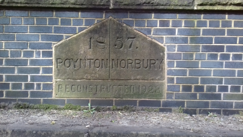
Boundary stone on Norbury Hollow Bridge
II
Boundary stone:dated 1857 reset 1928. Triangular topped, ashlar buff
sandstone block set in bridge parapet. Has inscription
Poynton/Norbury, erected 1857.
The stone lies partly in Norbury, Greater Manchester.
Listing NGR: SJ 93874 85373
External links are from the relevant listing authority and, where applicable, Wikidata. Wikidata IDs may be related buildings as well as this specific building. If you want to add or update a link, you will need to do so by editing the Wikidata entry.


Other nearby listed buildings
