Approximate Location Map
Large Map »
Latitude: 51.513 / 51°30'46"N
Longitude: -0.1237 / 0°7'25"W
OS Eastings: 530299
OS Northings: 181007
OS Grid: TQ302810
Mapcode National: GBR JC.DT
Mapcode Global: VHGQZ.S7ZH
Plus Code: 9C3XGV7G+5G
Entry Name: Nag's Head Public House
Listing Date: 1 February 1974
Grade: II
Source: Historic England
Source ID: 1277358
English Heritage Legacy ID: 407153
Also known as: Nag's Head, Covent Garden
The Nag's Head
The Nag's Head, Covent Garden
The Nags Head, Covent Garden
Nags Head
ID on this website: 101277358
Location: Strand, Westminster, London, WC2E
County: London
District: City of Westminster
Electoral Ward/Division: St James's
Parish: Non Civil Parish
Built-Up Area: City of Westminster
Traditional County: Middlesex
Lieutenancy Area (Ceremonial County): Greater London
Church of England Parish: St Paul Covent Garden
Church of England Diocese: London
Tagged with: Pub
TQ 3080 NE and 3081 SW CITY OF WESTMINSTER JAMES STREET, WC2
59/25 72/4
Nos. 10 and 10A (Nag's
1.2.74 Head Public House)
G.V. II
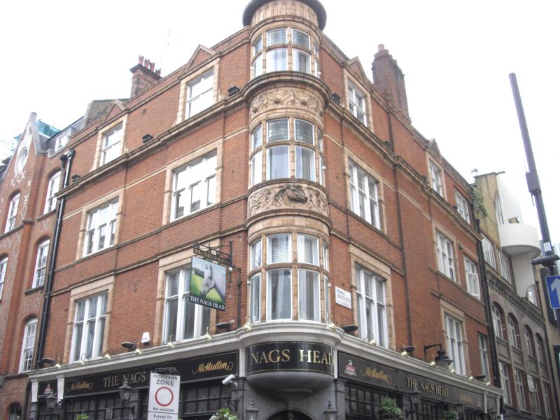
Corner public house and shop. c.1900 by P.E. Pilditch. Red brick with
terracotta dressings. Slate roof. Jacobethan style with feature of
corner tourelle. 3 storeys and half dormer attic. 3 windows wide, corner
tourelle and 4 window return to Floral Street. Ground floor with open shop
front (10A) and public house front with corner entrance, returned with
secondary entrance at end of Floral Street front, articulated by polished
granite pilasters carrying entablature. Upper floors have 3 light
mullioned terracotta dressed sash windows, whilst the tourelle has
mullioned-transomed with terracotta dressings and elaborate ornament to the
aprons. Terracotta entablature over 1st floor carried round tourelle.
Short sections of parapet link the pedimented half dormers whilst the
tourelle rises higher, finished off with ogee capped dome.
Survey of London; Vol. XXXVI.
Listing NGR: TQ3029481005
External links are from the relevant listing authority and, where applicable, Wikidata. Wikidata IDs may be related buildings as well as this specific building. If you want to add or update a link, you will need to do so by editing the Wikidata entry.


Other nearby listed buildings
