Approximate Location Map
Large Map »
Latitude: 53.6549 / 53°39'17"N
Longitude: -1.798 / 1°47'52"W
OS Eastings: 413444
OS Northings: 417623
OS Grid: SE134176
Mapcode National: GBR HVW5.JJ
Mapcode Global: WHCB1.CD0D
Plus Code: 9C5WM632+XQ
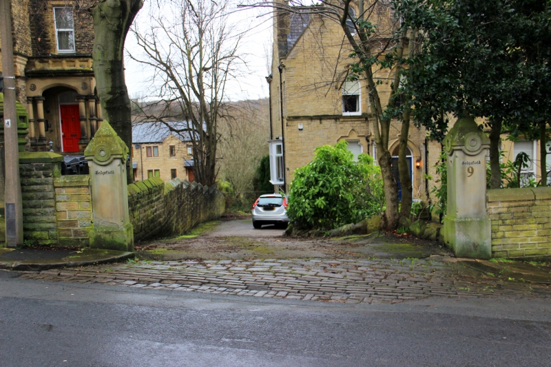
Entry Name: Gatepiers to Number 9
Listing Date: 29 September 1978
Grade: II
Source: Historic England
Source ID: 1278109
English Heritage Legacy ID: 406600
ID on this website: 101278109
Location: Birkby, Kirklees, West Yorkshire, HD2
County: Kirklees
Electoral Ward/Division: Greenhead
Parish: Non Civil Parish
Built-Up Area: Huddersfield
Traditional County: Yorkshire
Lieutenancy Area (Ceremonial County): West Yorkshire
Church of England Parish: Huddersfield Holy Trinity
Church of England Diocese: Leeds
Tagged with: Gatepost
QUEENS ROAD
1.
5113
(West Side)
Edgerton
Gatepiers to No 9
SE 1317 27/1122
II
2.
Mid Cl9. Ashlar. Pyramidal caps.
Listing NGR: SE1344417623
External links are from the relevant listing authority and, where applicable, Wikidata. Wikidata IDs may be related buildings as well as this specific building. If you want to add or update a link, you will need to do so by editing the Wikidata entry.


Other nearby listed buildings
