Approximate Location Map
Large Map »
Latitude: 53.4306 / 53°25'50"N
Longitude: -2.6559 / 2°39'21"W
OS Eastings: 356519
OS Northings: 392847
OS Grid: SJ565928
Mapcode National: GBR 9XWR.TY
Mapcode Global: WH98J.51KC
Plus Code: 9C5VC8JV+6M
Entry Name: Church of St Michael and All Angels
Listing Date: 9 August 1966
Last Amended: 19 July 1984
Grade: II
Source: Historic England
Source ID: 1278472
English Heritage Legacy ID: 405597
Also known as: St Michael's Church, Burtonwood
ID on this website: 101278472
Location: St Michael's Church, Burtonwood, Warrington, Cheshire, WA5
County: Warrington
Civil Parish: Burtonwood and Westbrook
Built-Up Area: Burtonwood
Traditional County: Lancashire
Lieutenancy Area (Ceremonial County): Cheshire
Church of England Parish: Burtonwood St Michael
Church of England Diocese: Liverpool
Tagged with: Church building
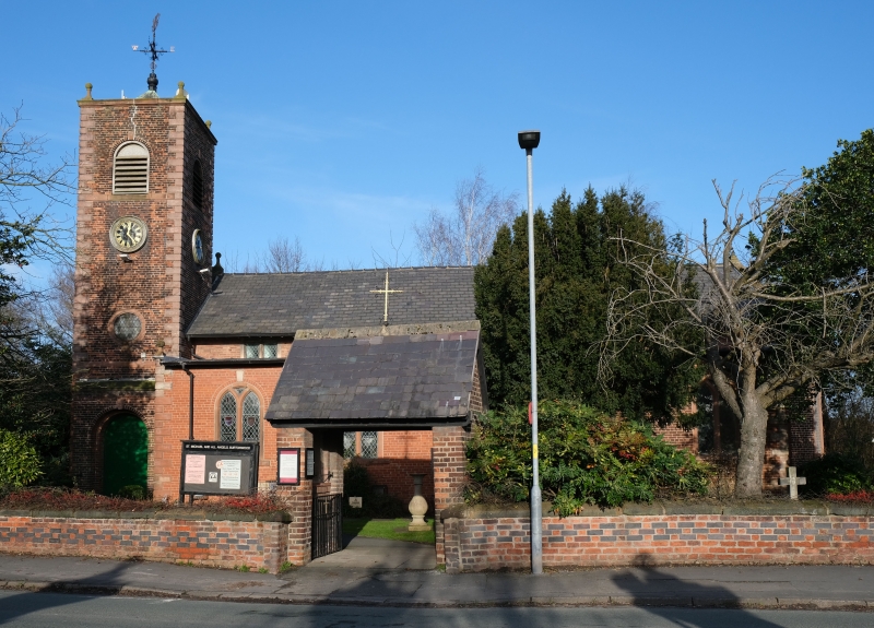
SJ 59 SE BURTONWOOD C.P. CHAPEL LANE
1/7 Church of St Michael
and All Angels
(Formerly listed as Church of
9/8/1966 St Michael)
II
Church, founded 1606, rebuilt 1716, south aisle by E.J.Dod added 1939.
Stone-dressed brick with grey slate roof to nave, copper to aisle.
West tower, simple nave, south aisle, small apsidal chancel. 3-stage
tower has circular windows to lower stage, clock and round-arched
bell-openings, simple cornice with ball-finials and ornate
weather-vane, south porch against tower has keystone inscribed Built
1716, rebuilt [porch only] 1939. Nave of 5 bays has round-headed
Y-tracery windows to north. South aisle has similar windows with
2-light square-headed windows to clerestorey. 2 round-arched windows
to chancel.
Interior. Tuscan south arcade of 1939 by Dod: simple round
chancel-arch; hammer-beam nave trusses have iron rods for tension
members. C20 armigerous glass; fragments of C17 church are preserved
in apse.
When inspected (1984) the church was undergoing major repair and
strengthening, having been damaged by coal-mining subsidence.
Listing NGR: SJ5651992847
External links are from the relevant listing authority and, where applicable, Wikidata. Wikidata IDs may be related buildings as well as this specific building. If you want to add or update a link, you will need to do so by editing the Wikidata entry.


Other nearby listed buildings
