Approximate Location Map
Large Map »
Latitude: 51.2104 / 51°12'37"N
Longitude: -3.4811 / 3°28'52"W
OS Eastings: 296636
OS Northings: 146729
OS Grid: SS966467
Mapcode National: GBR LJ.41XL
Mapcode Global: VH5JY.MT1Z
Plus Code: 9C3R6G69+5H
Entry Name: No 1 and Attached Wall to North East
Listing Date: 4 July 1952
Last Amended: 30 September 1994
Grade: II
Source: Historic England
Source ID: 1279764
English Heritage Legacy ID: 391149
ID on this website: 101279764
Location: Higher Town, Somerset, TA24
County: Somerset
District: Somerset West and Taunton
Civil Parish: Minehead
Built-Up Area: Minehead
Traditional County: Somerset
Lieutenancy Area (Ceremonial County): Somerset
Tagged with: Building
MINEHEAD
SS9646 CHURCH STEPS
900-1/3/14 (West side)
04/07/52 No.1
and attached wall to north-east
(Formerly Listed as:
CHURCH STEPS
(West side)
No.1)
GV II
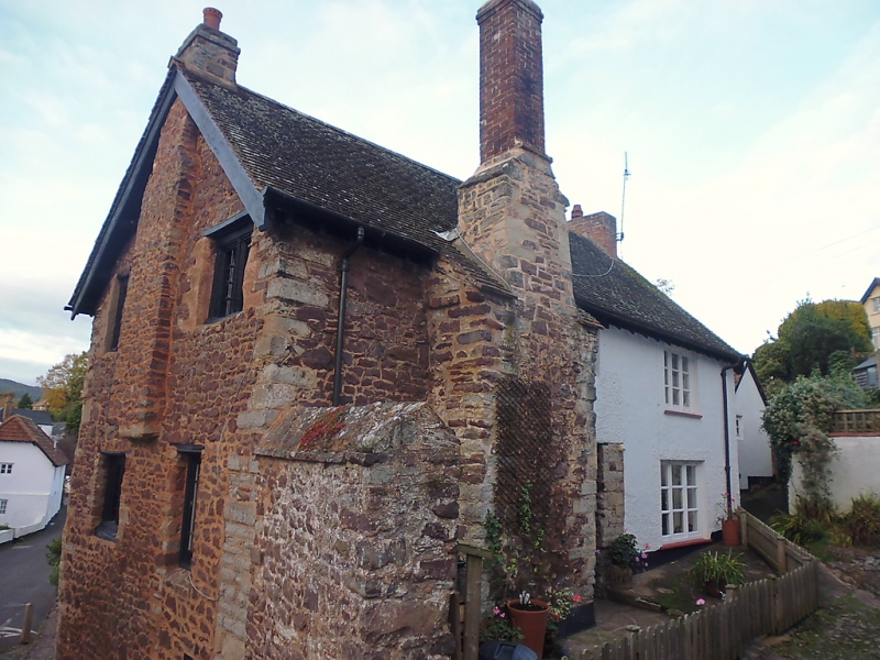
House. C16. Red sandstone rubble with some limestone, rendered
to the north-east; C20 gabled plain tile roof with exposed
rafter-ends; large external rubblestone stack off-set at and
above the eaves with brick shaft to front (north-east) facade;
rubblestone corbelled stack to first-floor left return.
2-unit plan with entry to right of hall with lateral stack to
left of door, stair bay projecting to rear and first-floor
room with corbelled stack.
2 storeys; 3-window range. Flat arches to mostly 2-light
hollow-moulded pegged oak-framed windows with C20 leaded
lights, some with grilles; similar small single-light window
at eaves level to stair bay at rear. To right of the main
stack a restored C16 chamfered oak doorcase and a planked and
studded door with strap hinges, over it a small single-light
window in an oak frame; to the far right are two C19
three-light casement windows.
INTERIOR: not inspected but noted as have a stone spiral stair
to the rear.
SUBSIDIARY FEATURES: a rubblestone wall approx 2m high and 3m
long is attached to the south-east corner.
HISTORY: in 1731 the Poor Rate became so burdensome that the
parish meeting was convinced that it would be more economical
to gather the poor together in a workhouse, so they leased
Punter's tenement at the foot of Church Steps for a rent of
»6.5s per annum.
(Binding H: Minehead: A New History: Minehead: 1977-: 136).
Listing NGR: SS9663646729
External links are from the relevant listing authority and, where applicable, Wikidata. Wikidata IDs may be related buildings as well as this specific building. If you want to add or update a link, you will need to do so by editing the Wikidata entry.


Other nearby listed buildings
