Approximate Location Map
Large Map »
Latitude: 51.4621 / 51°27'43"N
Longitude: -2.5976 / 2°35'51"W
OS Eastings: 358576
OS Northings: 173845
OS Grid: ST585738
Mapcode National: GBR C7G.HR
Mapcode Global: VH88M.XJL1
Plus Code: 9C3VFC62+RW
Entry Name: Numbers 2 to 12 and Attached Front Walls, Piers and Railings
Listing Date: 4 March 1977
Last Amended: 30 December 1994
Grade: II
Source: Historic England
Source ID: 1280617
English Heritage Legacy ID: 379198
ID on this website: 101280617
Location: Kingsdown, Bristol, BS6
County: City of Bristol
Electoral Ward/Division: Cotham
Parish: Non Civil Parish
Built-Up Area: Bristol
Traditional County: Gloucestershire
Lieutenancy Area (Ceremonial County): Bristol
Church of England Parish: Bristol St Matthew and St Nathanael
Church of England Diocese: Bristol
Tagged with: Building
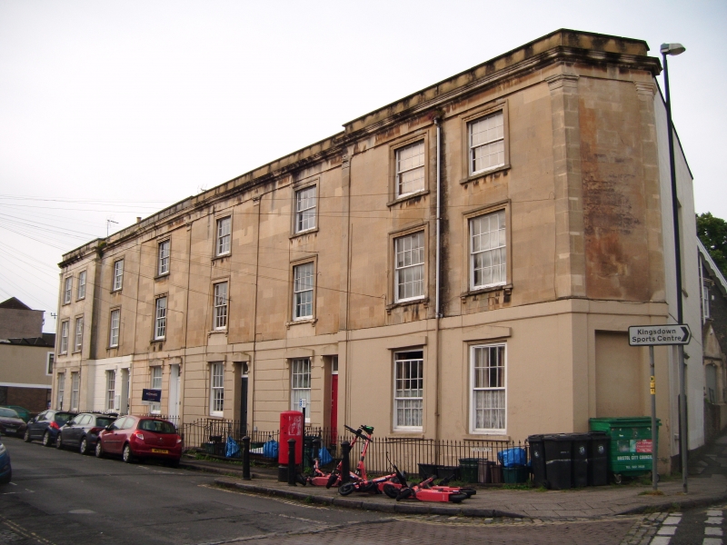
BRISTOL
ST5873NE CLEVEDON TERRACE, Kingsdown
901-1/5/1475 (South West side)
04/03/77 Nos.2-12 (Even)
and attached front walls, piers and
railings
(Formerly Listed as:
CLEVEDON TERRACE
Nos.2-12 (Even))
GV II
Terrace of 6 houses. c1830. Limestone ashlar, rendered party
wall stacks and a pantile valley roof. Double-depth plan. Late
Georgian style. Each of 3 storeys; 1-window range, end houses
have 2-window range.
A late formal terrace has projecting ends with splayed corner
doorways, pilasters with capitals to a frieze, cornice and
parapet, and banded rustication to the ground floor, plain on
the end houses. Right-hand doorways have fluted brackets to
lintels with triangular tops, rectangular overlights and doors
with 2 tall panels; windows have similar lintels, architraves
to the upper floors with bracketed cills, with brackets and
cornices on the first floor; 8/8-pane sashes, some horned. C20
shop front to No.12. INTERIOR not inspected.
SUBSIDIARY FEATURES: attached front walls, piers and railings.
Not shown on Ashmead's 1828 Map of Bristol. Shares a common
plan and similar elevation with Nos 1-11 opposite (qv).
Listing NGR: ST5857673845
External links are from the relevant listing authority and, where applicable, Wikidata. Wikidata IDs may be related buildings as well as this specific building. If you want to add or update a link, you will need to do so by editing the Wikidata entry.


Other nearby listed buildings
