Approximate Location Map
Large Map »
Latitude: 51.7341 / 51°44'2"N
Longitude: -1.9877 / 1°59'15"W
OS Eastings: 400945
OS Northings: 203933
OS Grid: SP009039
Mapcode National: GBR 2PD.890
Mapcode Global: VHB2J.HNJZ
Plus Code: 9C3WP2M6+JW
Entry Name: Stable Range Approximately 20 Metres South West of the Grange
Listing Date: 24 May 1993
Grade: II
Source: Historic England
Source ID: 1281012
English Heritage Legacy ID: 365128
ID on this website: 101281012
Location: Stratton, Cotswold, Gloucestershire, GL7
County: Gloucestershire
District: Cotswold
Civil Parish: Cirencester
Traditional County: Gloucestershire
Lieutenancy Area (Ceremonial County): Gloucestershire
Church of England Parish: Stratton St Peter
Church of England Diocese: Gloucester
Tagged with: Stable
CIRENCESTER
SP0003 STRATTON
578-1/2/368 Stable range approx 20m SW of The
Grange
GV II
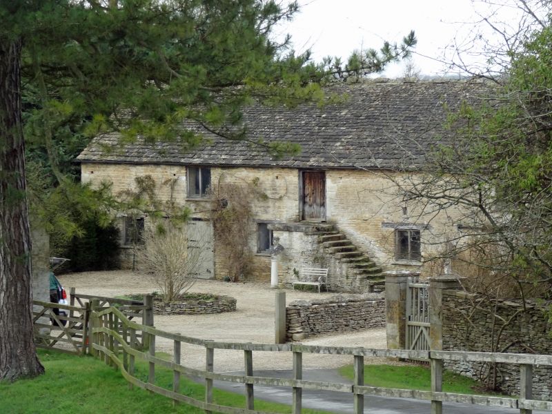
Stable range. Late C18/early C19. Coursed squared limestone
rubble; stone slate roof with vented stone ridge. 2-storey
range with two C20 2-light timber windows to first floor, four
similar windows, one now blocked, to ground floor. Ground
floor has two C20 sliding plank doors; plank door to first
floor reached via external stone stair to centre left.
Rudimentary quoins to left and right angles. INTERIOR has
continuous timber trough, probably early C19, full length of
building broken only at central dividing wall; east end
undivided and with continuous feeding rack; west end later
subdivided into looseboxes. Stone sett floor, roughly
chamfered beams, grain chute to centre. First floor has gaps
along north wall for hayracks below; 10-bay butt-purlin roof
with plank ridge, last 2 trusses to west C20 replacements.
Listing NGR: SP0094503933
External links are from the relevant listing authority and, where applicable, Wikidata. Wikidata IDs may be related buildings as well as this specific building. If you want to add or update a link, you will need to do so by editing the Wikidata entry.


Other nearby listed buildings
