Approximate Location Map
Large Map »
Latitude: 51.2868 / 51°17'12"N
Longitude: 0.286 / 0°17'9"E
OS Eastings: 559510
OS Northings: 156664
OS Grid: TQ595566
Mapcode National: GBR XH.QT3
Mapcode Global: VHHPM.XX2F
Plus Code: 9F3277PP+PC
Entry Name: Stone Cottage
Listing Date: 3 May 1984
Grade: II
Source: Historic England
Source ID: 1281408
English Heritage Legacy ID: 357278
ID on this website: 101281408
Location: Ightham, Tonbridge and Malling, Kent, TN15
County: Kent
District: Tonbridge and Malling
Civil Parish: Ightham
Built-Up Area: Ightham
Traditional County: Kent
Lieutenancy Area (Ceremonial County): Kent
Church of England Parish: Ightham St Peter
Church of England Diocese: Rochester
Tagged with: Cottage
TQ 5956 IGHTHAM THE STREET
5/18 (north side)
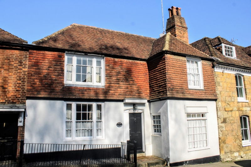
Stone Cottage
GV
II
C18. House with C19 wing to right. Rendered ground floor, tile-hung first floor.
Hipped plain tiled roof. Two storeys; one window front to left and also to wing.
Tripartite sash window to left, single sash on first floor to right, C19 shop front on
ground floor. Central half-glazed door with bracketted hood.
Listing NGR: TQ5950656662
External links are from the relevant listing authority and, where applicable, Wikidata. Wikidata IDs may be related buildings as well as this specific building. If you want to add or update a link, you will need to do so by editing the Wikidata entry.


Other nearby listed buildings
