Latitude: 51.8475 / 51°50'51"N
Longitude: -1.3552 / 1°21'18"W
OS Eastings: 444512
OS Northings: 216744
OS Grid: SP445167
Mapcode National: GBR 7WJ.066
Mapcode Global: VHCX6.GTDK
Plus Code: 9C3WRJXV+2W
Entry Name: The Woodstock Arms Public House
Listing Date: 13 February 1969
Last Amended: 27 July 1988
Grade: II
Source: Historic England
Source ID: 1281434
English Heritage Legacy ID: 253152
ID on this website: 101281434
Location: Woodstock, West Oxfordshire, OX20
County: Oxfordshire
District: West Oxfordshire
Civil Parish: Woodstock
Built-Up Area: Woodstock
Traditional County: Oxfordshire
Lieutenancy Area (Ceremonial County): Oxfordshire
Church of England Parish: Woodstock
Church of England Diocese: Oxford
Tagged with: Pub
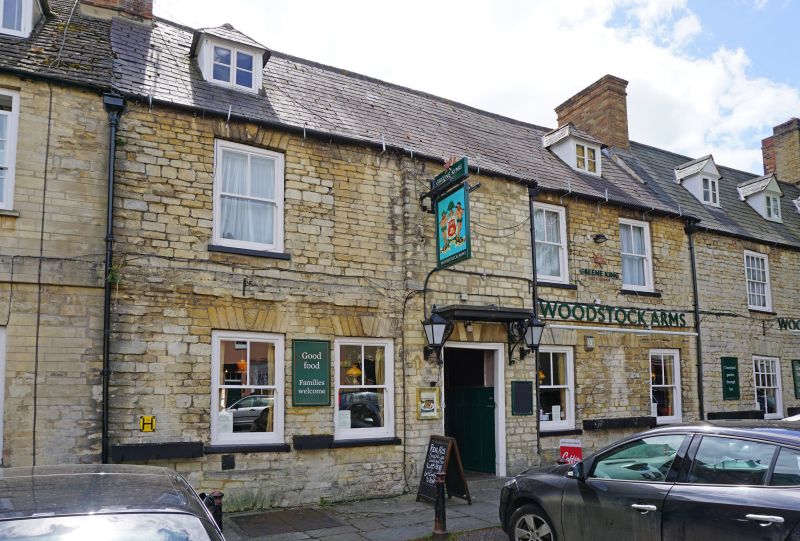
WOODSTOCK MARKET STREET
SP4416NW, SP4416NE (South side)
9/160, 10/160 Nos.6 and 8 (The Woodstock
13/02/69 Arms Public House)
(Formerly listed as No.6, No.8
(Woodstock Arms))
GV II
Two houses, now public house. Late C17/early C18 to right (No.6) and early C18
to left. No.6 of coursed limestone rubble; gabled Welsh slate roof; C19 and C20
brick end stacks. 2-unit plan. 2 storeys and attic; 3-window range. Flat stone
arch and scrolled wrought-iron brackets to flat hood over C20 central door. Flat
stone arches over early C19 eight-pane sashes, and over horned late C19
plate-glass sash to right. 3 late C19 gabled roof dormers with 2-light
casements. No.8 of similar materials, with dressed masonry to front and brick
end stack. 2-unit plan. 2 storeys and attic; 5-window range. Flat stone arch
over C19 six-panelled door to centre, and mid late C19 two-pane sashes; two
mid/late C19 hipped roof dormers. C18 two-storey wings to rear, with external
end stack of stone finished in brick to No.8. Interior: chamfered beads and open
fireplace with chamfered bressumer to No.8. First floor not inspected but likely
to be of interest.
Listing NGR: SP4451216744
External links are from the relevant listing authority and, where applicable, Wikidata. Wikidata IDs may be related buildings as well as this specific building. If you want to add or update a link, you will need to do so by editing the Wikidata entry.


Other nearby listed buildings