Approximate Location Map
Large Map »
Latitude: 55.3091 / 55°18'32"N
Longitude: -1.9118 / 1°54'42"W
OS Eastings: 405698
OS Northings: 601670
OS Grid: NU056016
Mapcode National: GBR H721.XN
Mapcode Global: WHB0Q.LTVC
Plus Code: 9C7W835Q+J7
Entry Name: 4, Market Place
Listing Date: 25 August 1987
Grade: II
Source: Historic England
Source ID: 1281762
English Heritage Legacy ID: 236648
ID on this website: 101281762
Location: Rothbury, Northumberland, NE65
County: Northumberland
Civil Parish: Rothbury
Built-Up Area: Rothbury
Traditional County: Northumberland
Lieutenancy Area (Ceremonial County): Northumberland
Church of England Parish: Upper Coquetdale
Church of England Diocese: Newcastle
Tagged with: Building
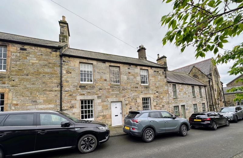
ROTHBURY MARKET PLACE
NU 0501
25/302 No. 4
GV II
House, early C19. Squared stone with tooled dressings; Welsh slate roof.
2 storeys, 3 bays, slightly irregular. Left-of-centre flush-panelled door;
16-pane sash windows except for blind window above door. All openings in
chamfered alternating-block surrounds. Coped right gable; stepped-and-corniced
right end stack with rendered shaft.
Listing NGR: NU0569801670
External links are from the relevant listing authority and, where applicable, Wikidata. Wikidata IDs may be related buildings as well as this specific building. If you want to add or update a link, you will need to do so by editing the Wikidata entry.


Other nearby listed buildings
