Approximate Location Map
Large Map »
Latitude: 51.4516 / 51°27'5"N
Longitude: -2.5869 / 2°35'12"W
OS Eastings: 359311
OS Northings: 172680
OS Grid: ST593726
Mapcode National: GBR C9L.WG
Mapcode Global: VH88N.3SR1
Plus Code: 9C3VFC27+M6
Entry Name: Shakespeare Inn
Listing Date: 8 December 1972
Grade: II
Source: Historic England
Source ID: 1282049
English Heritage Legacy ID: 380788
ID on this website: 101282049
Location: Box Makers Yard, Bristol, BS1
County: City of Bristol
Electoral Ward/Division: Central
Parish: Non Civil Parish
Built-Up Area: Bristol
Traditional County: Somerset
Lieutenancy Area (Ceremonial County): Bristol
Church of England Parish: St Mary Redcliffe with Temple, Bristol and St John the Baptist, Bedminster
Church of England Diocese: Bristol
Tagged with: Pub
BRISTOL
ST5972 VICTORIA STREET
901-1/42/331 (North East side)
08/12/72 No.78
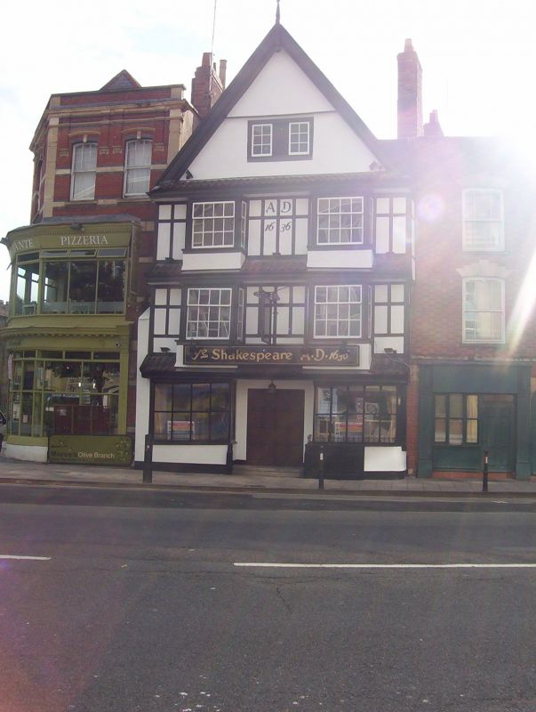
Shakespeare Inn
GV II
House, now public house. Early C17, dated 1636 on front,
extensively restored 1950, re-roofed 1992. Timber box-frame
with roughcast, 2 rubble lateral stacks each side, topped with
brick, and a pantile roof. Double fronted gable end facing the
street, formerly a right-hand stair between the stacks, and
front and back rooms; left-hand stacks from previous house to
that side.
3 storeys, cellar and attic; 2-bay range. A symmetrical front
divided by pantiled pents to each floor, boxed eaves, wide
central doorway with 2-leaf 1950 studded door, and square
3-storey bays. The bases of timber posts flank doorway to
inside of bays, which have 2-leaf cellar doors with strap
hinges; first- and second-floor 4/8-pane sashes, with 6/6/6
sliding sashes to attic beneath an original moulding.
INTERIOR: largely 1950 behind the frontage, with a new stair;
moulded first- and second-floor beams. Through-purlin roof
with diagonal braces, nails and pegging. Timber barrel-run
down into the cellar from the street. The original plan form
is found in C17 merchants' houses after 1660s, for example in
King Street.
(Gomme A, Jenner M and Little B: Bristol, An Architectural
History: Bristol: 1979-: 87; Winstone R: Bristol As It Was:
Bristol: 1879-: PL 75).
Listing NGR: ST5931172680
External links are from the relevant listing authority and, where applicable, Wikidata. Wikidata IDs may be related buildings as well as this specific building. If you want to add or update a link, you will need to do so by editing the Wikidata entry.


Other nearby listed buildings
