Approximate Location Map
Large Map »
Latitude: 50.5169 / 50°31'0"N
Longitude: -3.752 / 3°45'7"W
OS Eastings: 275887
OS Northings: 70034
OS Grid: SX758700
Mapcode National: GBR QJ.1V4B
Mapcode Global: FRA 371P.L3G
Plus Code: 9C2RG68X+Q6
Entry Name: 70, East Street
Listing Date: 1 September 1992
Grade: II
Source: Historic England
Source ID: 1282920
English Heritage Legacy ID: 376050
ID on this website: 101282920
Location: Ashburton, Teignbridge, Devon, TQ13
County: Devon
District: Teignbridge
Civil Parish: Ashburton
Built-Up Area: Ashburton
Traditional County: Devon
Lieutenancy Area (Ceremonial County): Devon
Church of England Parish: Ashburton St Andrew
Church of England Diocese: Exeter
Tagged with: Building
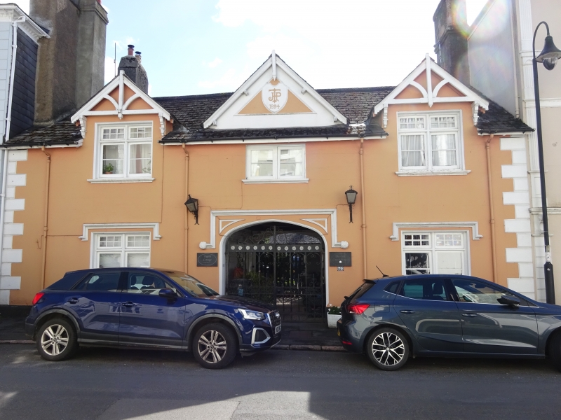
ASHBURTON
SX7570 EAST STREET
849-1/9/73 (South side)
No.70
GV II
Former coach-house and stable, now converted to living
accommodation for hotel next door at No 68 (qv). Dated 1894.
Solid rendered walls, lined to imitate masonry. Slated roof.
Rendered chimney on each gable end. Symmetrical, with covered
carriage entrance flanked by room at either side. Buildings on
all 3 sides of courtyard to rear. 2 storeys, 3 windows wide.
In centre, 4-centred arch with moulded spandrels; square
hoodmould with sponge-like terminals; patterned iron gates.
Outer windows in each storey have mullioned-and-transomed wood
casements, the lower lights 2-paned, those above 6-paned.
Ground storey windows have square hood-moulds; those in upper
storey rise above the eaves where they are finished with
gables decorated with projecting braced and bracketed
bargeboards. Over the centre arch a small 2-light wood
casement window. On the roof above it a blind triangular gable
with moulded bargeboards; in its centre the date 1894 and
monogram HPT. Whole front flank by raised quoins. Courtyard
buildings altered; stone rubble range to left.
Listing NGR: SX7588770034
External links are from the relevant listing authority and, where applicable, Wikidata. Wikidata IDs may be related buildings as well as this specific building. If you want to add or update a link, you will need to do so by editing the Wikidata entry.


Other nearby listed buildings
