Latitude: 54.1034 / 54°6'12"N
Longitude: -3.2327 / 3°13'57"W
OS Eastings: 319494
OS Northings: 468207
OS Grid: SD194682
Mapcode National: GBR 5NVZ.XS
Mapcode Global: WH72P.94V2
Plus Code: 9C6R4Q38+9W
Entry Name: General Offices, Technical/Commercial, at Vickers Ship and Engineering Limited
Listing Date: 6 May 1976
Last Amended: 20 December 1993
Grade: II
Source: Historic England
Source ID: 1283036
English Heritage Legacy ID: 388418
ID on this website: 101283036
Location: Barrow Island, Westmorland and Furness, Cumbria, LA14
County: Westmorland and Furness
District: Barrow-in-Furness
Electoral Ward/Division: Barrow Island
Parish: Non Civil Parish
Built-Up Area: Barrow-in-Furness
Traditional County: Lancashire
Lieutenancy Area (Ceremonial County): Cumbria
Church of England Parish: Barrow-in-Furness St John the Evangelist
Church of England Diocese: Carlisle
Tagged with: Architectural structure
BARROW IN FURNESS
SD1968 BRIDGE ROAD, Barrow Island 708-1/13/33 (South side) 06/05/76 General offices, technical/commercial, at VSEL (Formerly Listed as: BRIDGE ROAD Vickers Shipbuilding Group (building dated 1872 only))
GV II
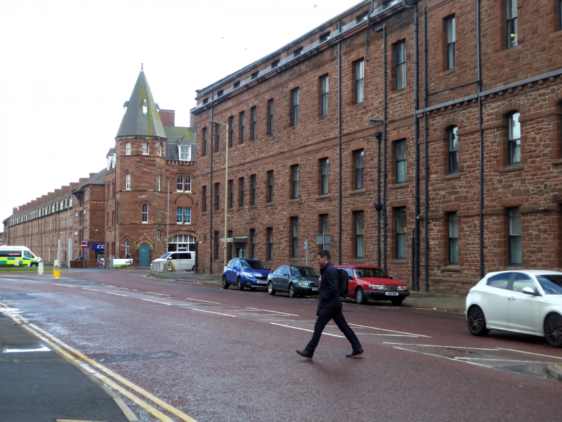
Shipyard office buildings. Dated 1872 with extensive additions of c1900. Originally for the Barrow Iron Shipbuilding Co, additions for Vickers, Sons and Maxim Ltd. Red sandstone with ashlar dressings, slate and corrugated sheet roofs. L-shaped range with Bridge Road front of 3 storeys and attic and 5 storeys; 10:12:11 windows to 1st floor. Left return, facing Michaelson Road steps down to single-storey; five 3-bay gables and 12-bay block aligned with road. Bridge Road front: lower 2 storeys of the centre and gateway to right are the original office and entrance of the shipyard: chamfered plinth, impost band to square-headed ground-floor windows mostly having plain sashes; segmentally-arched windows to 1st floor, some of them in pairs; corbel table. Later 2nd floor has square-headed windows with double keystones, ashlar entablature. Shipyard Gate in projection on right with iron gates and steel girder, to left of gate is a roundel with rope moulding, stag's head and 'BSBC 1872'; above gate are paired windows and corbel table. Shipyard Gate is set in the 5-storey section with its 4th-floor windows having double keystones under ashlar frieze; the top 2 storeys at right end have been altered. Left end stack set behind C20 elevator shaft. Left part of range is set back slightly and has square-headed, 4-pane sashes; single keystones to 1st floor and double keystones to 2nd. Frieze over 1st floor windows; entablature with small windows in the parapet; skylights; ashlar gable copings. Left return: end gable of front range has giant pilasters; double windows to centre bay and tripartite window to attic having segmental arch, keystone and hood-mould. 3-storey gable to left with architraved roundel and inclined corbel tables to coped gable parapet; three 1-storey gables beyond have segmentally-arched windows under similar roundels and gables. Range completed by 12-bay shed aligned with road: continuous, chamfered sill band to large segmentally-arched windows with keystones; oversailing course and blocks support gutter; gable copings. End of this 12-bay shed has 3 gables. The Barrow Iron Shipbuilding Company was formed in 1870; the office building fronted the shipbuilding yard with its slipways into Walney Channel. Contemporary plans show that much of the site was occupied by sheds relating to timberwork. The company was taken over by the Naval Construction and Armaments Co Ltd in 1888 and then by Vickers Sons and Co in 1896 (became Vickers, Sons and Maxim Ltd in 1897). In this later ownership the yard saw massive development during a time of major expansion in the world's navies. Much of the building here is likely to date from c1900. The buildings are all now given over to administration and drawing offices; those fronting Michaelson Road are included primarily for the contribution made to the industrial scene by their roadside elevations. (The Barrow in Furness Almanack and Tide Tables: Barrow in Furness: 1886-: 86-89 & LITHOGRAPHS).
Listing NGR: SD1949468207
External links are from the relevant listing authority and, where applicable, Wikidata. Wikidata IDs may be related buildings as well as this specific building. If you want to add or update a link, you will need to do so by editing the Wikidata entry.


Other nearby listed buildings