Approximate Location Map
Large Map »
Latitude: 51.5618 / 51°33'42"N
Longitude: -1.7921 / 1°47'31"W
OS Eastings: 414509
OS Northings: 184793
OS Grid: SU145847
Mapcode National: GBR YPP.PT
Mapcode Global: VHB3L.W0GJ
Plus Code: 9C3WH665+P5
Entry Name: 1, 2 and 3, Bristol Street including yard walls
Listing Date: 17 February 1970
Grade: II
Source: Historic England
Source ID: 1283917
English Heritage Legacy ID: 318680
ID on this website: 101283917
Location: Swindon, Wiltshire, SN1
County: Swindon
Electoral Ward/Division: Central
Parish: Central Swindon South
Built-Up Area: Swindon
Traditional County: Wiltshire
Lieutenancy Area (Ceremonial County): Wiltshire
Church of England Parish: Swindon New Town
Church of England Diocese: Bristol
Tagged with: Building
This list entry was subject to a Minor Enhancement on 23/04/2020
SU 1484 NE
6/20
BRISTOL STREET (south side)
SWINDON
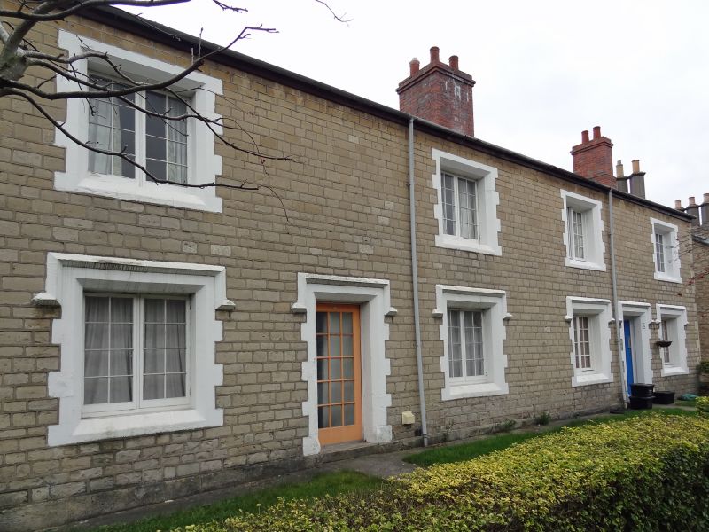
Nos. 1, 2 and 3 including yard walls
17.2.70
GV
II
In order to house the workforce for the new Great Western Railway works, IK Brunel designed a new village to the south of the railway line. Brunel’s early layout drawings of 1840 show a grid similar to the final plan of 12 terraces in six blocks on either side of the High Street (from 1893 Emlyn Square). Construction started in 1842, and by 1855 most of the buildings had been completed. Houses and cottages of different types were built, as well as lodging houses. Brunel himself designed only the first block of 1842 (4-25 Bristol Street); as it was visible from the railway line, this is in a more decorative style than the others.
The financial difficulties of the contractors JD & C Rigby, who undertook to build 300 cottages but only completed 130, delayed the completion of the village until the 1850s. The cottages to the west of Emlyn Square were built first (1842-1843), followed by those on the east side (1845-1847). The end blocks towards Emlyn Square, containing corner shops on the ground floor, were built in 1845-1847, and the remainder, mostly end blocks on the outer ends of the streets, were built in 1853-1855. In 1966, the local authority acquired the cottages from British Rail and restored them. The village is one of Britain’s best-preserved and architecturally most ambitious railway settlements.
Terrace of three cottages. 1845-1846 for Great Western Railway Company. Coursed limestone rubble with ashlar quoins. Slate roofs. Two storey. No. 1 double unit, Nos. 2 and 3 are single units. Twenty-pane doors inset on splay. Four-pane sashes. Stone rear yard walls and outbuildings. Extensively renovated c1974. Similar to Nos. 53-54 Bathampton Street (q.v.).
Listing NGR: SU1451484795
External links are from the relevant listing authority and, where applicable, Wikidata. Wikidata IDs may be related buildings as well as this specific building. If you want to add or update a link, you will need to do so by editing the Wikidata entry.


Other nearby listed buildings
