Latitude: 51.4327 / 51°25'57"N
Longitude: -2.1854 / 2°11'7"W
OS Eastings: 387209
OS Northings: 170422
OS Grid: ST872704
Mapcode National: GBR 1RH.0BK
Mapcode Global: VH96J.28J2
Plus Code: 9C3VCRM7+3V
Entry Name: Midland Bank
Listing Date: 1 December 1972
Last Amended: 1 August 1986
Grade: II
Source: Historic England
Source ID: 1284213
English Heritage Legacy ID: 315233
ID on this website: 101284213
Location: Corsham, Wiltshire, SN13
County: Wiltshire
Civil Parish: Corsham
Built-Up Area: Corsham
Traditional County: Wiltshire
Lieutenancy Area (Ceremonial County): Wiltshire
Church of England Parish: Greater Corsham
Church of England Diocese: Bristol
Tagged with: Bank building
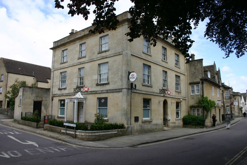
CORSHAM HIGH STREET ST 8770 (west side) 5/206 Nos 25 and 27 (Midland Bank) (formerly listed as No 27) 12.72 GV II
House, now bank, c1820-30, ashlar with low pitched slate hipped roof and 2 ashlar stacks. Three-storey 3-window range, square plan with formal fronts to south and east. Moulded cornice and parapet and each floor framed by raised angle strips, plinth, 2 floor bands and band under cornice. Originally 16-pane outer windows and 12-pane centre windows to both facades, but ground floor plate glass sashes replace original glazing bar sashes. Both fronts have arched centre doorway with fanlight. East front to High Street has 6-panel door. South front to Post Office Lane has 4-panel door and ornate cast-iron porch with tent roof. Pierced uprights, pierced Gothic top rail with pierced scroll frieze over with vase centrepiece. Old photographs show matching railings and gateway to Post Office Lane.
Listing NGR: ST8720370426
External links are from the relevant listing authority and, where applicable, Wikidata. Wikidata IDs may be related buildings as well as this specific building. If you want to add or update a link, you will need to do so by editing the Wikidata entry.


Other nearby listed buildings