Approximate Location Map
Large Map »
Latitude: 51.6207 / 51°37'14"N
Longitude: -1.1077 / 1°6'27"W
OS Eastings: 461867
OS Northings: 191700
OS Grid: SU618917
Mapcode National: GBR B26.8RV
Mapcode Global: VHCYH.RJ7D
Plus Code: 9C3WJVCR+7W
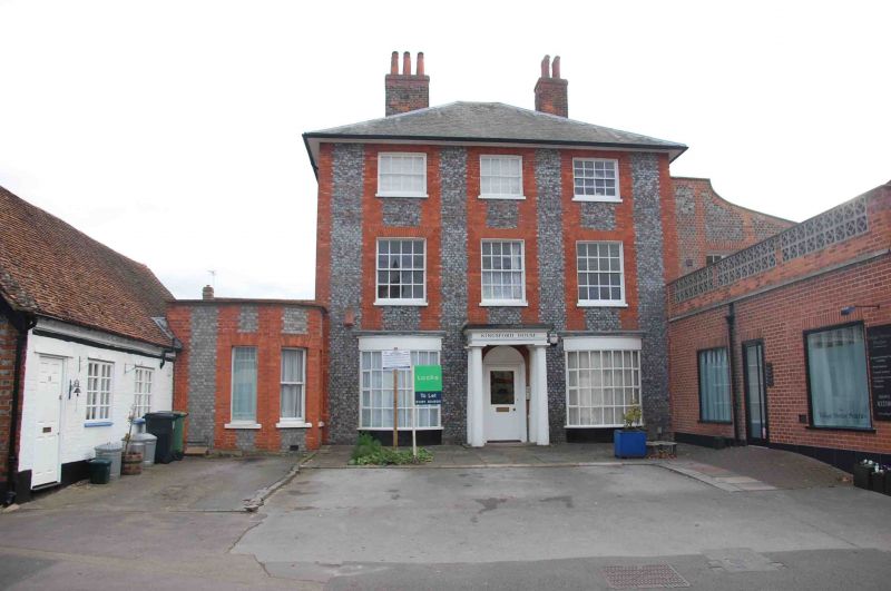
Entry Name: Kingsford House
Listing Date: 18 July 1963
Last Amended: 28 November 1985
Grade: II
Source: Historic England
Source ID: 1285775
English Heritage Legacy ID: 247763
ID on this website: 101285775
Location: Benson, South Oxfordshire, OX10
County: Oxfordshire
District: South Oxfordshire
Civil Parish: Benson
Built-Up Area: Benson
Traditional County: Oxfordshire
Lieutenancy Area (Ceremonial County): Oxfordshire
Church of England Parish: Benson
Church of England Diocese: Oxford
Tagged with: House
BENSON HIGH STREET
SU6191 (South side)
7/55 Nos.14 and 16 (Kingsford
18/07/63 House)
(Formerly listed as Kingsford
House)
GV II
House. Probably early C19. Grey brick with red brick dressings; Welsh slate
hipped roof; brick internal stacks to left and right returns. 3 storey, 3-window
range. Central 4-panel part-glazed door with square flat porch on Doric columns.
C20 bow windows to left and right. 16-pane sashes to first and second floor.
Interior not inspected. Wing to right of grey brick with red brick dressings
with concave volute parapet to roof.
Listing NGR: SU6186791700
External links are from the relevant listing authority and, where applicable, Wikidata. Wikidata IDs may be related buildings as well as this specific building. If you want to add or update a link, you will need to do so by editing the Wikidata entry.


Other nearby listed buildings
