Approximate Location Map
Large Map »
Latitude: 50.9105 / 50°54'37"N
Longitude: -0.1534 / 0°9'12"W
OS Eastings: 529920
OS Northings: 113964
OS Grid: TQ299139
Mapcode National: GBR JMY.XQ8
Mapcode Global: FRA B6KP.Q30
Plus Code: 9C2XWR6W+6J
Entry Name: The Parish Church of St John the Baptist
Listing Date: 28 October 1957
Grade: I
Source: Historic England
Source ID: 1286147
English Heritage Legacy ID: 302433
ID on this website: 101286147
Location: St John the Baptist's Church, Clayton, Mid Sussex, BN6
County: West Sussex
District: Mid Sussex
Civil Parish: Hassocks
Traditional County: Sussex
Lieutenancy Area (Ceremonial County): West Sussex
Church of England Parish: Clayton with Keymer
Church of England Diocese: Chichester
Tagged with: Church building Anglo-Saxon architecture
CLAYTON UNDERHILL LANE
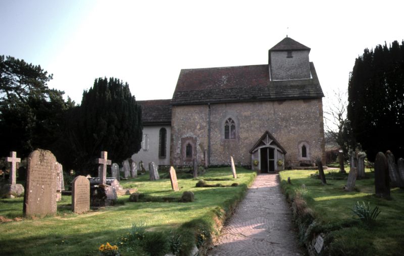
1.
5405
The Parish Church of
St John the Baptist
TQ 21 SE 22/41 28.10.57
I
2.
Chancel, nave with north aisle, shingled bell turret at west end and north porch. nave
Largely pre-Conquest, but the chancel is late C13 and the north aisle C15. The nave
has very fine wall paintings of 1150 circa.
Listing NGR: TQ2991813967
External links are from the relevant listing authority and, where applicable, Wikidata. Wikidata IDs may be related buildings as well as this specific building. If you want to add or update a link, you will need to do so by editing the Wikidata entry.


Other nearby listed buildings
