Latitude: 53.3258 / 53°19'32"N
Longitude: -1.2186 / 1°13'7"W
OS Eastings: 452139
OS Northings: 381267
OS Grid: SK521812
Mapcode National: GBR MYXZ.YJ
Mapcode Global: WHDF0.7NYR
Plus Code: 9C5W8QGJ+8G
Entry Name: Ruins of Thorpe Salvin Hall
Listing Date: 29 July 1966
Last Amended: 15 October 1986
Grade: II*
Source: Historic England
Source ID: 1286372
English Heritage Legacy ID: 335839
ID on this website: 101286372
Location: Thorpe Salvin, Rotherham, South Yorkshire, S80
County: Rotherham
Civil Parish: Thorpe Salvin
Built-Up Area: Thorpe Salvin
Traditional County: Yorkshire
Lieutenancy Area (Ceremonial County): South Yorkshire
Church of England Parish: Thorpe Salvin St Peter
Church of England Diocese: Sheffield
Tagged with: House Architectural structure
THORPE SALVIN LADYFIELD ROAD SK58SW (north side, off) 5/77 Ruins of Thorpe Salvin 29.7.66 Hall (formerly listed as part of Ruins of Thorpe Salvin Hall and gatehouse)
GV II*
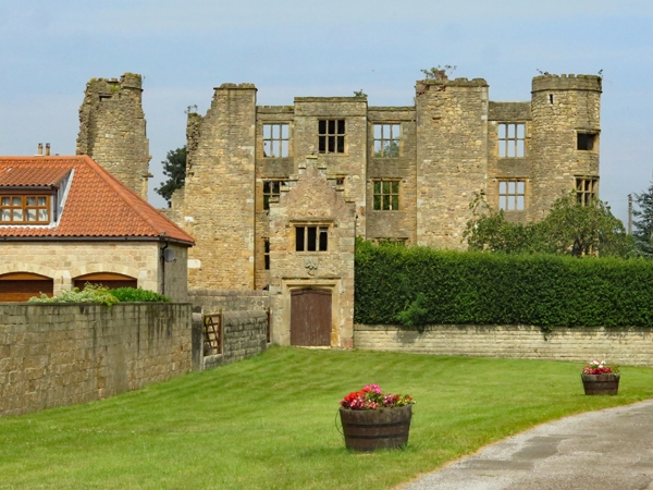
Ruined mansion. Mid-late C16. For Hercy Sandford (d1582). Rubble limestone, no roof. 3-storey, 9-bay symmetrical south wall of courtyard-plan mansion having round corner turrets, projections for external stacks and central porch; bases of rear corner turrets survive, that on right linked by section of plinth wall. In Tudor domestic style with transomed, ovolo-moulded mullioned windows mostly of 3 lights. Large quoins, chamfered plinth. Central porch projection has doorway with double-chamfered surround and Tudor-arched lintel with hoodmould; blocked 3-light mullioned window over has hoodmould. Transomed 1st-floor window with hoodmould now has wooden pigeon holes; transomed 2nd-floor window beneath dripcourse. 3 bays to each side have blind central stack projections surmounted by sections of mulled friezes and with diagonally-set stack plinths; bay 2 collapsed above ground floor. Turret at left end ruined, that on right intact and with windows set on the curve, 2nd-floor window without mullions, string course beneath rebuilt parapet. Right return: plinth remains and has projection for stop-chamfered doorway; base of turret on right. Left return: base of rear turret with chamfered square-headed doorway attached. Interior: rear of facade has large ground-floor fireplaces of which the relieving arches remain; triangular- headed fireplaces to upper floors. Heraldic panels on the gatehouse (q.v.) point to the date of construction being 1565-82. The building was sold to Sir Edward Osborne in 1636. His successor Thomas Osborne, Earl of Danby lived there until after his marriage; he became Charles II's chief minister and was created Duke of Leeds in 1694 after which time the family moved to Kiveton Park. A scheduled Ancient Monument. M. Girouard, Robert Smythson and The Elizabethan Country House, 1983, p119- 20. J. Hunter, South Yorkshire: The History and Topography of the Deanery of Doncaster, 1828-31, p310. N. Pevsner, BOE, 1967, p515.
Listing NGR: SK5213481285
External links are from the relevant listing authority and, where applicable, Wikidata. Wikidata IDs may be related buildings as well as this specific building. If you want to add or update a link, you will need to do so by editing the Wikidata entry.


Other nearby listed buildings