Approximate Location Map
Large Map »
Latitude: 52.6142 / 52°36'50"N
Longitude: -0.532 / 0°31'55"W
OS Eastings: 499487
OS Northings: 302832
OS Grid: SK994028
Mapcode National: GBR FW8.499
Mapcode Global: WHGM2.SKT8
Plus Code: 9C4XJF79+M5
Entry Name: The Steward's House
Listing Date: 23 May 1967
Grade: II
Source: Historic England
Source ID: 1286845
English Heritage Legacy ID: 232910
ID on this website: 101286845
Location: Collyweston, North Northamptonshire, PE9
County: North Northamptonshire
Civil Parish: Collyweston
Built-Up Area: Collyweston
Traditional County: Northamptonshire
Lieutenancy Area (Ceremonial County): Northamptonshire
Church of England Parish: Collyweston St Andrew
Church of England Diocese: Peterborough
Tagged with: House
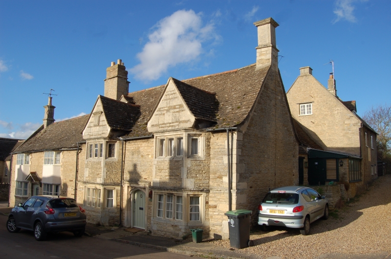
COLLYWESTON HIGH STREET
SK9902 (North side)
8/45 The Steward's House
23/05/67
GV II
House. Early C17 and late C17. Squared coursed limestone and limestone ashlar
with Collyweston slate roof. Originally 2-unit plan, 2 storeys. 2-window range
of C17, five light, 2-storey canted bay windows with ovolo moulded stone
mullions. Ashlar banded gablets over, with moulded kneelers. Central plank door
has 4-centred arch-head, with moulded stone surround. Moulded string course
above windows, stepping up over doorway. Evidence of blocked fire window to far
left. Ashlar end stack, with moulded cornices to right and shared brick and
stone stack to left. Rear wing is probably late C17. Interior has open fireplace
with bressumer to ground floor left with winder stair adjacent. First floor
room to right, has C17 fireplace with chamfered stone surround and 4-centred
arch-head.
(RCHM: An Inventory of Architectural Monuments in North Northamptoshire: p34)
Listing NGR: SK9948702832
External links are from the relevant listing authority and, where applicable, Wikidata. Wikidata IDs may be related buildings as well as this specific building. If you want to add or update a link, you will need to do so by editing the Wikidata entry.


Other nearby listed buildings
