Latitude: 50.7672 / 50°46'1"N
Longitude: -2.5649 / 2°33'53"W
OS Eastings: 360258
OS Northings: 96548
OS Grid: SY602965
Mapcode National: GBR PV.53C6
Mapcode Global: FRA 57J1.SPS
Plus Code: 9C2VQC8P+V2
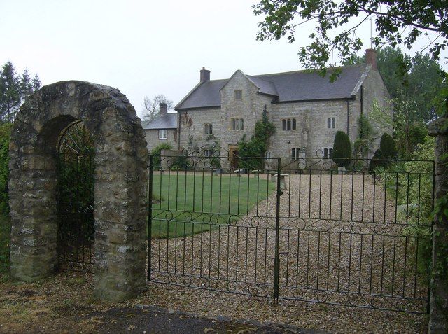
Entry Name: West Cruxton Farmhouse
Listing Date: 26 January 1956
Grade: II*
Source: Historic England
Source ID: 1287680
English Heritage Legacy ID: 401643
ID on this website: 101287680
Location: Cruxton, Dorset, DT2
County: Dorset
Civil Parish: Maiden Newton
Traditional County: Dorset
Lieutenancy Area (Ceremonial County): Dorset
Church of England Parish: Maiden Newton and Valleys
Church of England Diocese: Salisbury
Tagged with: Farmhouse
MAIDEN NEWTON SY 69 NW CRUXTON
3/89 West Cruxton Farmhouse 26-1-56 GV II*
Manor Farmhouse. Late C16, with C19 extension at south end. Flint and dressed stone walls, with stone base. Clay-tile roofs with stone gable-copings and moulded kneelers. C20 brick stacks at both gable ends. 2 storeys and attics. 5 windows, all with hollow-chamfered stone mullions in square frames, depressed- arch heads, fixed lead-lights with opening metal casements at centre. Ground floor openings: 2-, 2-, porch, 3-, buttress, 3-light, small buttress. Gabled porch at centre, to full height, entrance has a depressed arch in a square head, with returned label over. Plank-and-muntin door, studded, with a weatherboard at foot of door. Rear elevation has a staircase tower, with 3-light and 4-light stone mullions. Extension of house at south end, C19. Rubble-stone with brick dressings, brick stack at gable end. 3-light cast-iron casement with glazing-bars, segmental head.
Interior: Some doorways with original oak frames and 4-centred heads. Some C17 panelling (RCHM) (RCHM Dorset I, p.153 (ll).)
Listing NGR: SY6025896548
External links are from the relevant listing authority and, where applicable, Wikidata. Wikidata IDs may be related buildings as well as this specific building. If you want to add or update a link, you will need to do so by editing the Wikidata entry.


Other nearby listed buildings