Approximate Location Map
Large Map »
Latitude: 52.3084 / 52°18'30"N
Longitude: -2.15 / 2°9'0"W
OS Eastings: 389866
OS Northings: 267820
OS Grid: SO898678
Mapcode National: GBR 1DW.96X
Mapcode Global: VH928.P76Q
Plus Code: 9C4V8R5X+9X
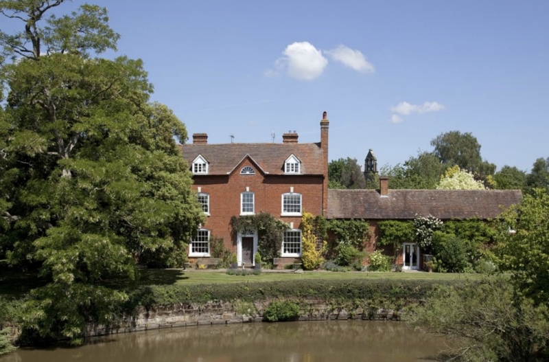
Entry Name: Church Farmhouse
Listing Date: 26 June 1985
Grade: II
Source: Historic England
Source ID: 1288199
English Heritage Legacy ID: 400316
ID on this website: 101288199
Location: Elmbridge, Wychavon, Worcestershire, WR9
County: Worcestershire
District: Wychavon
Civil Parish: Elmbridge
Traditional County: Worcestershire
Lieutenancy Area (Ceremonial County): Worcestershire
Church of England Parish: Elmbridge
Church of England Diocese: Worcester
Tagged with: Farmhouse
ELMBRIDGE CP ELMBRIDGE
SO 86 NE
5/35 Church Farmhouse
- II
Farmhouse. Early C19 with C20 alterations. Brick, tile roof, gable
end stacks. Two storeys with attic lit by two gabled dormers and lunette
in central gable; three windows: two 20-pane sashes flank a 12-pane sash,
under segmental heads with keystones; central entrance has pedimented
doorcase with a radially glazed fanlight, 4-panelled door.
Listing NGR: SO8986667820
External links are from the relevant listing authority and, where applicable, Wikidata. Wikidata IDs may be related buildings as well as this specific building. If you want to add or update a link, you will need to do so by editing the Wikidata entry.


Other nearby listed buildings
