Approximate Location Map
Large Map »
Latitude: 53.6551 / 53°39'18"N
Longitude: -1.8503 / 1°51'1"W
OS Eastings: 409988
OS Northings: 417631
OS Grid: SE099176
Mapcode National: GBR HVJ5.6H
Mapcode Global: WHCB0.KD39
Plus Code: 9C5WM44X+2V
Entry Name: 96-104, Lamb Hall Road
Listing Date: 29 September 1978
Grade: II
Source: Historic England
Source ID: 1288430
English Heritage Legacy ID: 340103
ID on this website: 101288430
Location: Upper Hirst, Kirklees, West Yorkshire, HD3
County: Kirklees
Electoral Ward/Division: Golcar
Parish: Non Civil Parish
Built-Up Area: Huddersfield
Traditional County: Yorkshire
Lieutenancy Area (Ceremonial County): West Yorkshire
Church of England Parish: Longwood St Mark the Evangelist
Church of England Diocese: Leeds
Tagged with: Building
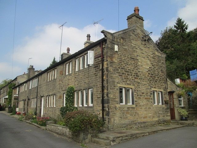
LAMB HALL ROAD
1.
5113
(North Side)
Longwood
Nos 96 to 104 (even)
SE 0917 25/775
II
2.
C18. Hammer-dressed stone. Pitched stone slate roof. Coped gables on cut
kneelers. 2 storeys. One range each of 4-light stone mullioned windows.
One 2-light stone mullioned window each on 1st floor (No 98's blocked).
Listing NGR: SE0998817630
External links are from the relevant listing authority and, where applicable, Wikidata. Wikidata IDs may be related buildings as well as this specific building. If you want to add or update a link, you will need to do so by editing the Wikidata entry.


Other nearby listed buildings
