Latitude: 51.4883 / 51°29'17"N
Longitude: -1.0985 / 1°5'54"W
OS Eastings: 462686
OS Northings: 176974
OS Grid: SU626769
Mapcode National: GBR B3R.R2J
Mapcode Global: VHCZ2.XV3H
Plus Code: 9C3WFWQ2+8H
Entry Name: Craigside
Listing Date: 19 June 1984
Grade: II
Source: Historic England
Source ID: 1288796
English Heritage Legacy ID: 398754
ID on this website: 101288796
Location: Whitchurch-on-Thames, West Berkshire, RG8
County: West Berkshire
Civil Parish: Pangbourne
Built-Up Area: Pangbourne
Traditional County: Berkshire
Lieutenancy Area (Ceremonial County): Berkshire
Church of England Parish: Pangbourne with Tidmarsh and Sulham
Church of England Diocese: Oxford
Tagged with: Building
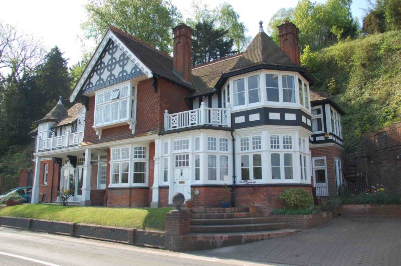
SU 67 NW PANGBOURNE SHOOTER'S HILL
(south side)
2/32
No. 49 (Craigside)
And No.51
G.V. II
2 houses. Circa 1890. Red brick with some gauged,window heads, and first floor
planted timbers and tile banging. Tile roof with gablet to left. Irregular
plan. 2 storeys and attic. Semi dormer to left with oriel window and hipped
roof with lead finial, semi dormer off-centre to left with French casements
and segmental pediment, dormer off-centre to left with 4-light casement and
segmental pediment, and 4 stacks with arched panels. Main elements include:
Projecting wing to right resting on ground floor timber columns and central
curved bay, first floor mullioned and transomed oriel window, and patterned
planted timbers in gable end with decorated barge boards. Loggia to left with
half glazed door set back to right, two 2-light windows set back to left, and
balcony above. Balcony off-centre to right with door below, and octagonal corner
turret to right with mullioned and transomed window on each floor, pyrammidal
roof and lead finial. These houses are part of a group sometimes known as
'The Seven Deadly Sins'. Included for group value. B.0.E, Berks, p.192;
Berkshire Architectural Guide, Betjeman and Piper, Murray, 1949, p.137.
Listing NGR: SU6268676973
External links are from the relevant listing authority and, where applicable, Wikidata. Wikidata IDs may be related buildings as well as this specific building. If you want to add or update a link, you will need to do so by editing the Wikidata entry.


Other nearby listed buildings