Approximate Location Map
Large Map »
Latitude: 50.7004 / 50°42'1"N
Longitude: -1.5346 / 1°32'4"W
OS Eastings: 432960
OS Northings: 89072
OS Grid: SZ329890
Mapcode National: GBR 78W.2T8
Mapcode Global: FRA 77N7.CXN
Plus Code: 9C2WPF28+44
Entry Name: Fort Albert
Listing Date: 28 March 1994
Grade: II*
Source: Historic England
Source ID: 1291552
English Heritage Legacy ID: 393095
Also known as: Cliff End Fort
ID on this website: 101291552
Location: Isle of Wight, PO40
County: Isle of Wight
Civil Parish: Freshwater
Traditional County: Hampshire
Lieutenancy Area (Ceremonial County): Isle of Wight
Church of England Parish: Freshwater All Saints
Church of England Diocese: Portsmouth
Tagged with: Fort Palmerston fort
FRESHWATER
SZ38NW CLIFF END
1354-0/4/207 Fort Albert
II* .
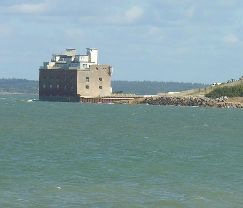
Former Artillery fort, 1854 and attached torpedo house, 1886,
with alteration 1940s and conversion to residence 1970s-80s.
rick foundations and superstructure with granite base,
additions of 1940s and 1970s-80s in blockwork or concrete; all
now rendered except for western face. Original block is a
broad irregular chevron in plan, pointing west. Three storeys
surmounted by a warhead. Above this now rise a lift shaft
(1970s) to serve a smaller fourth storey of flat-roofed
buildings in the centre, constructed for anti-aircraft
purposes 1940s, terminated by 2 direction towers. Prominent
1980s addition with slate false pitches attached to north of
northern turret. Masking the eastern return of the original
build at the north end is the single-storey torpedo house,
with mass concrete roof shallowly pitched against fort,
covering a brick half-vault. Winding room beyond this is
flat-roofed. The massive walls are pierced by cambered-headed
gunports (to seaward) and masket loops (to landward) which are
now glazed (1970s-80s). Some of these retain granite sills
with sunk margins. To landward, where render conceals all
detail, only 2 storeys are visible. The southern end of this
face is treated as one bay with tripartite windows on each
floor, then come 2 bays of simple openings, all these being
taller than to seaward, then a gate-tower with small windows
over the plain first floor entrance. Lift shaft in line with
gate-tower in similar idiom. Re-entrant angle with the
northern end of this front is filled by the ancillary rooms of
the torpedo house, now converted to a circulation area.
Wallhead is a covered gallery with small musket loops and
sloping crown terminating in bartisans. The northern end of
this front was treated as a single bay but is now largely
concealed by the torpedo house. This is also rendered, over
brick, and has no external features of note except on its
northern side where large modern sliding doors mark the
storage area, and the small projection beyond the north wall
of the fort shows the outline of the arch through which the
torpedoes were launched. The northern facade is of two bays,
the ports now blocked at ground floor level. The granite base
shows a descending sequence of housings for the sleepers of
the Brennan torpedo launch rail, now dismantled. At the
wallhead is a cantilevered former searchlight position of the
1940s. The western facade is of seven bays, the ground floor
ports blocked. Souther facade of two bays. The INTERIOR was
divided into seven brick compartments on each floor but has
now been substantially altered in conversion to residential
use. The ports have splayed inner reveals in two stages. The
torpedo house has a semi-vaulted recess cut out of the foot of
the fort wall and rods inset into the vaulting; the passage to
the winding room has rectangular sinkings in its walls; all
are presumably connected to the operation of the wire-guided
Brennan torpedo. It stands over the original moat, which
allowed construction of subterranean chambers that may
survive. History: built on an artificial island to defend the
western approach to Portsmouth, opposite Hurst Castle, New
Forest D, Lymington CP, Hants (qv), which was strengthened at
the same time. Intended to house 29 guns in four tiers, it was
among the last gun-towers constructed in England and was
rapidly rendered obsolete by advances in gunnery. In 1886 it
was chosen as one of our UK locations for the Brennan
wire-guided torpedo which had a range sufficient to close the
strait. This too became obsolete and was dismantled in 1906.
Small guns only were mounted on the fort which was finally
closed in 1957. Important as a late example of its type and
for the Brennan installation. A Cantwell and P Sprack, Solent
.. Papers No 2 (Fortress Study Group, 1986).
Listing NGR: SZ3296089072
External links are from the relevant listing authority and, where applicable, Wikidata. Wikidata IDs may be related buildings as well as this specific building. If you want to add or update a link, you will need to do so by editing the Wikidata entry.


Other nearby listed buildings
