Approximate Location Map
Large Map »
Latitude: 54.9061 / 54°54'21"N
Longitude: -1.376 / 1°22'33"W
OS Eastings: 440108
OS Northings: 556996
OS Grid: NZ401569
Mapcode National: GBR VDL.83
Mapcode Global: WHD55.TYY9
Plus Code: 9C6WWJ4F+CJ
Entry Name: Former Presbyterian Chapel
Listing Date: 10 November 1978
Last Amended: 17 October 1994
Grade: II
Source: Historic England
Source ID: 1292024
English Heritage Legacy ID: 391632
ID on this website: 101292024
Location: Sunderland, Tyne and Wear, SR1
County: Sunderland
Electoral Ward/Division: Hendon
Parish: Non Civil Parish
Built-Up Area: Sunderland
Traditional County: Durham
Lieutenancy Area (Ceremonial County): Tyne and Wear
Church of England Parish: Hendon
Church of England Diocese: Durham
Tagged with: Chapel
NZ 4057,
920-1/12/229
SUNDERLAND,
VILLIERS STREET (West side)
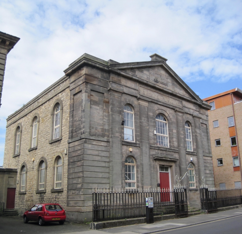
No.19, former Presbyterian Chapel
(Formerly Listed as: VILLIERS STREET (West side),
No.19)
10/11/78
GV
II
Formerly known as: Chapel of St George VILLIERS STREET.
Shown on O.S. as West Park College (Technical School).
Presbyterian Chapel, now business training centre, with
railings. Dated 1825. By James Hogg. Ashlar front, coursed
squared stone returns and rear with ashlar dressings; roof not
visible. Classical style, symmetrical.
EXTERIOR: Two storeys, three windows in five bays. Pedimented central
projection has giant pilasters defining bays, the central
wider with double panelled door and overlight with glazing
bars in projecting plain stone surround with cornice and
blocking course; round-headed window above with glazing bars
has slightly recessed surround; similar windows in plain
surrounds in flanking bays; sill strings between pilasters and
in recessed outer bays which have rusticated ground floor and
recessed tall rectangular panels above. Top entablature, with
blank panel over central bay and restored Roman numerals
MDCCCXXV in pediment; former letters (? presbyterian chapel)
removed. Corniced block rises behind pediment peak; blocking
course over outer pilasters and stepped down over outer bays.
Returns have single ashlar bay as on front, completing angle
treatment, and continue in rubble with round-headed windows
which have raised stone surrounds with key and impost blocks;
rear, also rubble, has shallow apse.
(Milburn GE and Miller ST: Sunderland River, Town and People:
Sunderland: 1988-: 156; Buildings of England: Pevsner (revised
Williamson): County Durham: Harmondsworth: 1983-: 452).
Listing NGR: NZ4010856996
External links are from the relevant listing authority and, where applicable, Wikidata. Wikidata IDs may be related buildings as well as this specific building. If you want to add or update a link, you will need to do so by editing the Wikidata entry.


Other nearby listed buildings
