Latitude: 54.9059 / 54°54'21"N
Longitude: -2.9413 / 2°56'28"W
OS Eastings: 339739
OS Northings: 557206
OS Grid: NY397572
Mapcode National: GBR 7CXQ.04
Mapcode Global: WH7ZW.SYKF
Plus Code: 9C6VW345+9F
Entry Name: 72-80, Etterby Street
Listing Date: 22 March 1974
Last Amended: 11 April 1994
Grade: II
Source: Historic England
Source ID: 1292394
English Heritage Legacy ID: 386740
ID on this website: 101292394
Location: Edentown, Cumberland, Cumbria, CA3
County: Cumberland
District: Carlisle
Parish: Non Civil Parish
Built-Up Area: Carlisle
Traditional County: Cumberland
Lieutenancy Area (Ceremonial County): Cumbria
Church of England Parish: Carlisle Stanwix St Michael
Church of England Diocese: Carlisle
Tagged with: Building
CARLISLE
NY3957SE ETTERBY STREET, Stanwix 671-1/3/151 (North side) 22/03/74 Nos.72-80 (Even) (Formerly Listed as: ETTERBY STREET (North side) Nos.6-84 (Even))
GV II
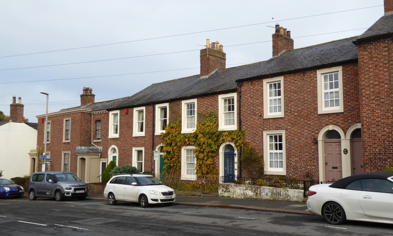
5 houses forming part of a terrace. 1840s. Flemish bond brickwork with light headers on chamfered stone plinth; Nos 78 and 80 have a partly modillioned cornice. Welsh slate roofs; original shared ridge and end brick chimney stacks. 2 storeys, 2 bays each, except No.76 which has 3 bays; stepped with the slope of the hill in groups. Left and right doorways have various C20 doors, Nos 72-76 with fanlights, some of which are radial patterned, all in pilastered surrounds with false keys and imposts. Nos 78 and 80 have projecting stuccoed porches with depressed pointed arches. Sash windows, some with glazing bars in painted stone architraves. No.72 has paired doorway, that on right to through passage. No.76 has a right through-passage door of similar detail to the front door. No.78 has a right through-passage plank door in painted stone surround. The central common 2 bays of Nos 78 and 80 project. INTERIORS not inspected. These properties are not on the 1840 tithe map, but are on the first edition OS map 1865.
Listing NGR: NY3973957206
External links are from the relevant listing authority and, where applicable, Wikidata. Wikidata IDs may be related buildings as well as this specific building. If you want to add or update a link, you will need to do so by editing the Wikidata entry.


Other nearby listed buildings