Latitude: 53.4742 / 53°28'27"N
Longitude: -2.2378 / 2°14'16"W
OS Eastings: 384313
OS Northings: 397523
OS Grid: SJ843975
Mapcode National: GBR DLK.4L
Mapcode Global: WHB9G.LXLZ
Plus Code: 9C5VFQF6+MV
Entry Name: Lass O Gowrie Public House
Listing Date: 6 June 1994
Grade: II
Source: Historic England
Source ID: 1293175
English Heritage Legacy ID: 387980
Also known as: Lass O'Gowrie
The Lass O'Gowrie, Manchester
ID on this website: 101293175
Location: University, Manchester, Greater Manchester, M1
County: Manchester
Electoral Ward/Division: City Centre
Parish: Non Civil Parish
Built-Up Area: Manchester
Traditional County: Lancashire
Lieutenancy Area (Ceremonial County): Greater Manchester
Church of England Parish: Hulme The Ascension
Church of England Diocese: Manchester
Tagged with: Pub
MANCHESTER
SJ8497NW CHARLES STREET 698-1/32/45 (North side) Lass O'Gowrie PH
II
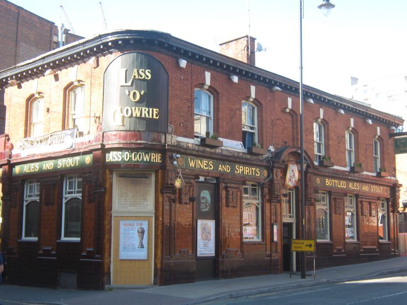
Public house. Mid C19 altered c.1900. Red brick with dressings of deep red, orange and green glazed terracotta, slate roof. Rectangular plan on island site with chamfered corners to west end. Two storeys over basement, a 6-window facade to Charles Street and 2-window west end, the ground floor with richly-decorated tiled cladding including pilaster panels with debased Ionic caps which have pendants with bell-flower decoration, a doorway (offset left of centre) in neo-Baroque style with open segmental pediment, and a frieze of green tiling with raised lettering ("WINES AND SPIRITS" "BOTTLED ALES AND STOUT" at the front, "LASS-O-GOWRIE" at the corner, "ALES AND STOUT" at the west end); windows with engraved plate-glass (3 to the right, one to the left and 2 at the west end); corner doorway altered as window; segmental-headed windows at 1st floor, all with keystones, that over the door blind and the others all recessed 4-pane sashes; prominent modillioned cornice carried round. Hipped roof with ridge chimney. Interior altered but basement still in use as brewery.
Listing NGR: SJ8431397523
External links are from the relevant listing authority and, where applicable, Wikidata. Wikidata IDs may be related buildings as well as this specific building. If you want to add or update a link, you will need to do so by editing the Wikidata entry.


Other nearby listed buildings